
Geographic Region: FRANCE
Feature: ERODED PEAK
|
Geographic Region: FRANCE Feature: ERODED PEAK |
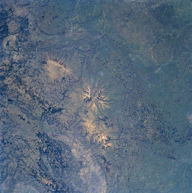 |
| NM23-703-204 Massif Central, Puys Volcanic Chain, France Winter/Spring 1997 One of the series of 60 volcanic cones (center of image) of the Puys Volcanic Chain in the Massif Central in south-central France can be seen in this southeast-looking low-oblique view. The Massif Central is a great mountainous plateau covering 33000 sq. miles (85470 sq. km). It is the most rugged and geologically diverse region in France. This ancient eroded upland of granite rock rises up to 2600 feet (800 meters) above sea level. Volcanism began in the region about 20 million years ago. Eruptions of the Puys Volcanic Chain began about 150000 years ago. Strombolian and Pelean type eruptions occurred and finally ceased about 6000 years ago. Lava flows spread out [radial drainage pattern] in all directions as can be seen on the image. Elevations of most of the Puys (peaks) are in excess of 4000 feet (1200 meters). The Puys Volcanic Chain stretches north to south 25 miles (40 km) and is part of the Auvergne Mountains. Many of the volcanic chain's peaks have scarcely been altered by erosion and remain virtually intact. Pasturelands, shrubs, and even extensive forests cover the area. The unique landscape of the whole region brings in thousands of tourists from around the world. |
| Images: | All Available Images Low-Resolution 391k |
|
| Mission: | NM23 |
|
| Roll - Frame: | 703 - 204 |
|
| Geographical Name: | FRANCE |
|
| Features: | ERODED PEAK |
|
| Center Lat x Lon: | 45.0N x 3.0E |
|
| Film Exposure: | N | N=Normal exposure, U=Under exposed, O=Over exposed, F=out of Focus |
| Percentage of Cloud Cover-CLDP: | 0 |
|
| Camera:: | HB |
|
| Camera Tilt: | LO | LO=Low Oblique, HO=High Oblique, NV=Near Vertical |
| Camera Focal Length: | 100 |
|
| Nadir to Photo Center Direction: | The direction from the nadir to the center point, N=North, S=South, E=East, W=West |
|
| Stereo?: | N | Y=Yes there is an adjacent picture of the same area, N=No there isn't |
| Orbit Number: | |
|
| Date: | 19970308 | YYYYMMDD |
| Time: | GMT HHMMSS |
|
| Nadir Lat: | N |
Latitude of suborbital point of spacecraft |
| Nadir Lon: | E |
Longitude of suborbital point of spacecraft |
| Sun Azimuth: | Clockwise angle in degrees from north to the sun measured at the nadir point |
|
| Space Craft Altitude: | nautical miles |
|
| Sun Elevation: | Angle in degrees between the horizon and the sun, measured at the nadir point |
|
| Land Views: | VOLCANO, PLATEAU, HILL |
|
| Water Views: | |
|
| Atmosphere Views: | |
|
| Man Made Views: | AGRICULTURE |
|
| City Views: | |
|
Photo is not associated with any sequences | ||
| NASA Home Page |
JSC Home Page |
JSC Digital Image Collection |
Earth Science & Remote Sensing |
|
This service is provided by the International Space Station program and the JSC Earth Science & Remote Sensing Unit, ARES Division, Exploration Integration Science Directorate.

|