
Geographic Region: BRAZIL
Feature: RES.,RIO PARANA,R. TIETE
|
Geographic Region: BRAZIL Feature: RES.,RIO PARANA,R. TIETE |
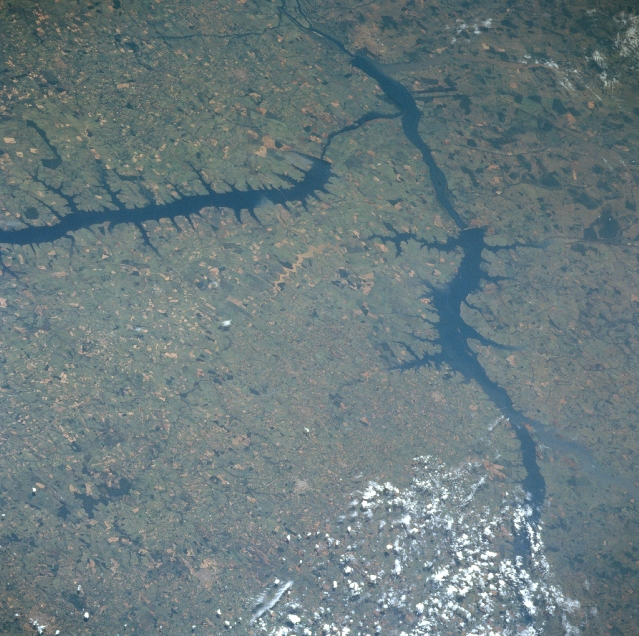 |
| NM22-737-012 Tiete River, Ilha Solteira and the Jupia Reservoirs, Brazil Fall 1996 The Parana River, which has the second largest drainage system in South America behind the Amazon, can be seen exiting the scene at the top center of the image. Near the bottom right portion of the image, the Rio Grande and Paranaiba Rivers join together to form the Parana. The large reservoir seen extending from just above the left center of the image to just above the center of the image is a new reservoir built on the Tiete River, which joins the Parana in the DeJupia Reservoir. The landscape in this scene is hilly to flat terrain and is an extensive agricultural region in Brazil. |
| Images: | All Available Images Low-Resolution 371k |
|
| Mission: | NM22 |
|
| Roll - Frame: | 737 - 12 |
|
| Geographical Name: | BRAZIL |
|
| Features: | RES.,RIO PARANA,R. TIETE |
|
| Center Lat x Lon: | 20.5S x 51W |
|
| Film Exposure: | N | N=Normal exposure, U=Under exposed, O=Over exposed, F=out of Focus |
| Percentage of Cloud Cover-CLDP: | 10 |
|
| Camera:: | HB |
|
| Camera Tilt: | LO | LO=Low Oblique, HO=High Oblique, NV=Near Vertical |
| Camera Focal Length: | 250 |
|
| Nadir to Photo Center Direction: | The direction from the nadir to the center point, N=North, S=South, E=East, W=West |
|
| Stereo?: | Y | Y=Yes there is an adjacent picture of the same area, N=No there isn't |
| Orbit Number: | |
|
| Date: | 19961125 | YYYYMMDD |
| Time: | GMT HHMMSS |
|
| Nadir Lat: | N |
Latitude of suborbital point of spacecraft |
| Nadir Lon: | E |
Longitude of suborbital point of spacecraft |
| Sun Azimuth: | Clockwise angle in degrees from north to the sun measured at the nadir point |
|
| Space Craft Altitude: | nautical miles |
|
| Sun Elevation: | Angle in degrees between the horizon and the sun, measured at the nadir point |
|
| Land Views: | |
|
| Water Views: | RESERVOIR, RIVER |
|
| Atmosphere Views: | |
|
| Man Made Views: | AGRICULTURE, DAM |
|
| City Views: | |
|
Photo is not associated with any sequences | ||
| NASA Home Page |
JSC Home Page |
JSC Digital Image Collection |
Earth Science & Remote Sensing |
|
This service is provided by the International Space Station program and the JSC Earth Science & Remote Sensing Unit, ARES Division, Exploration Integration Science Directorate.

|