
Geographic Region: BRAZIL
Feature: RES.,R. PARANAIBA,AGR.,CY
|
Geographic Region: BRAZIL Feature: RES.,R. PARANAIBA,AGR.,CY |
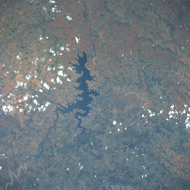 |
| NM22-737-010 Paranaiba River Reservoir, Brazil Fall 1996 One of many reservoirs on the Paranaiba River in Goias and Minas Gerais States in south-central Brazil, can be seen in this west-looking view. Brazil is in the process of building many new reservoirs on its river systems for hydroelectric power and irrigation. The Paranaiba River is 500 miles (805 km) long rising in west Minas Gerais State flowing generally west through an agricultural region before joining the Rio Grande to form the Parana River. Diamonds have been found along the course of the Paranaiba, that exits the scene at the top center of the image. The dark green colors seen in the view are densly covered vegetation areas and are most prominent towards the bottom center of the image. The more reddish colors, especially to the left of the reservoir, are exposed lateritic soils that dominate this region of Brazil. The small city of Itumbiara is barely discernible to the right of the river (north) at the "U" bend in the river just to the west of the reservoir dam. |
| Images: | All Available Images Low-Resolution 355k |
|
| Mission: | NM22 |
|
| Roll - Frame: | 737 - 10 |
|
| Geographical Name: | BRAZIL |
|
| Features: | RES.,R. PARANAIBA,AGR.,CY |
|
| Center Lat x Lon: | 18S x 49W |
|
| Film Exposure: | N | N=Normal exposure, U=Under exposed, O=Over exposed, F=out of Focus |
| Percentage of Cloud Cover-CLDP: | 5 |
|
| Camera:: | HB |
|
| Camera Tilt: | LO | LO=Low Oblique, HO=High Oblique, NV=Near Vertical |
| Camera Focal Length: | 250 |
|
| Nadir to Photo Center Direction: | NW | The direction from the nadir to the center point, N=North, S=South, E=East, W=West |
| Stereo?: | N | Y=Yes there is an adjacent picture of the same area, N=No there isn't |
| Orbit Number: | |
|
| Date: | 19961125 | YYYYMMDD |
| Time: | GMT HHMMSS |
|
| Nadir Lat: | N |
Latitude of suborbital point of spacecraft |
| Nadir Lon: | E |
Longitude of suborbital point of spacecraft |
| Sun Azimuth: | Clockwise angle in degrees from north to the sun measured at the nadir point |
|
| Space Craft Altitude: | nautical miles |
|
| Sun Elevation: | Angle in degrees between the horizon and the sun, measured at the nadir point |
|
| Land Views: | |
|
| Water Views: | RESERVOIR, RIVER |
|
| Atmosphere Views: | |
|
| Man Made Views: | AGRICULTURE, DAM |
|
| City Views: | |
|
Photo is not associated with any sequences | ||
| NASA Home Page |
JSC Home Page |
JSC Digital Image Collection |
Earth Science & Remote Sensing |
|
This service is provided by the International Space Station program and the JSC Earth Science & Remote Sensing Unit, ARES Division, Exploration Integration Science Directorate.

|