
Geographic Region: TURKMENISTAN
Feature: STRAIT OF KARA-BOGAZ GOL
|
Geographic Region: TURKMENISTAN Feature: STRAIT OF KARA-BOGAZ GOL |
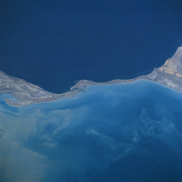 |
| NM22-735-039 Kara-Bogaz-Gol Bay, Caspian Sea, Turkmenistan Fall 1996-Winter 1997 A long, low, sandy isthmus separates the Caspian Sea (upper portion of the image) and the Kara-Bogaz-Gol Bay (lower portion of the image) in this west-looking view. The Caspian Sea is the largest inland sea in the world and is one and one-half times the size of all five Great Lakes combined. The Caspian Sea's surface is 92 feet (28 meters) below sea level. The Kara-Bogaz-Gol Bay covers an area of 7000 square miles (18130 square km) or about the size of Lake Ontario. This shallow bay is no more than 33 feet (10 meters) deep, but is 102 feet (31 meters) below sea level. Since the bay is lower than the Caspian Sea, water rushes into the Kara-Bogaz-Gol through a narrow channel visible on the image just to the left of center. The shallow bay acts as a natural evaporating basin in this arid region, depositing salts along its shores. |
| Images: | All Available Images Low-Resolution 313k |
|
| Mission: | NM22 |
|
| Roll - Frame: | 735 - 39 |
|
| Geographical Name: | TURKMENISTAN |
|
| Features: | STRAIT OF KARA-BOGAZ GOL |
|
| Center Lat x Lon: | 41.0N x 53.0E |
|
| Film Exposure: | N | N=Normal exposure, U=Under exposed, O=Over exposed, F=out of Focus |
| Percentage of Cloud Cover-CLDP: | 0 |
|
| Camera:: | HB |
|
| Camera Tilt: | 36 | LO=Low Oblique, HO=High Oblique, NV=Near Vertical |
| Camera Focal Length: | 100 |
|
| Nadir to Photo Center Direction: | NW | The direction from the nadir to the center point, N=North, S=South, E=East, W=West |
| Stereo?: | Y | Y=Yes there is an adjacent picture of the same area, N=No there isn't |
| Orbit Number: | 122 |
|
| Date: | 19961116 | YYYYMMDD |
| Time: | 070125 | GMT HHMMSS |
| Nadir Lat: | 39.9N |
Latitude of suborbital point of spacecraft |
| Nadir Lon: | 55.2E |
Longitude of suborbital point of spacecraft |
| Sun Azimuth: | 163 | Clockwise angle in degrees from north to the sun measured at the nadir point |
| Space Craft Altitude: | 202 | nautical miles |
| Sun Elevation: | 30 | Angle in degrees between the horizon and the sun, measured at the nadir point |
| Land Views: | DESERT |
|
| Water Views: | SEA, BAY, SEDIMENT, STRAIT |
|
| Atmosphere Views: | |
|
| Man Made Views: | |
|
| City Views: | |
|
Photo is not associated with any sequences | ||
| NASA Home Page |
JSC Home Page |
JSC Digital Image Collection |
Earth Science & Remote Sensing |
|
This service is provided by the International Space Station program and the JSC Earth Science & Remote Sensing Unit, ARES Division, Exploration Integration Science Directorate.

|