
Geographic Region: USA-ARIZONA
Feature: THEODORE ROOSEVELT LAKE
|
Geographic Region: USA-ARIZONA Feature: THEODORE ROOSEVELT LAKE |
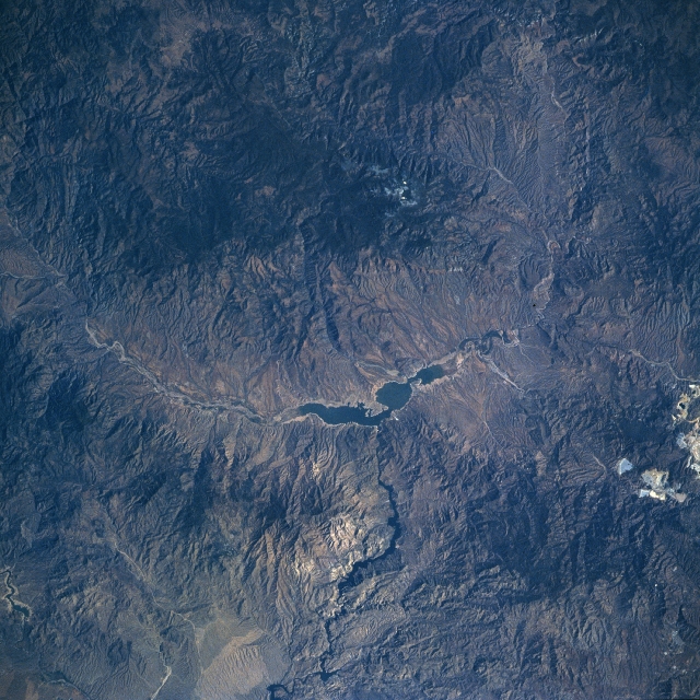 |
| NM22-727-071 Theodore Roosevelt Lake, Arizona, USA Fall-Winter 1996 Rugged mountainous terrain surrounds an elongated and irregular shaped Theodore Roosevelt Lake. This reservoir used to stretch for 30 miles (48 kilometers) but it is gradually shrinking in length as silt is accumulating at both ends of the lake. Theodore Roosevelt Lake is part of the Tonto drainage basin and is fed intermittently by the Salt River, which flows into the eastern end of the lake. The water from this manmade lake exists via the Theodore Roosevelt Dam, which is located towards the midway point along the south side of the lake. The Salt River continues westward, providing some of the water that is supplied to the greater Phoenix metropolitan area, located 55 miles (90 kilometers) west of the lake. The light colored terrain along the southeast side of the image shows scars on the landscape from the silver and copper mining activities near Globe. |
| Images: | All Available Images Low-Resolution 385k |
|
| Mission: | NM22 |
|
| Roll - Frame: | 727 - 71 |
|
| Geographical Name: | USA-ARIZONA |
|
| Features: | THEODORE ROOSEVELT LAKE |
|
| Center Lat x Lon: | 34.0N x 111W |
|
| Film Exposure: | N | N=Normal exposure, U=Under exposed, O=Over exposed, F=out of Focus |
| Percentage of Cloud Cover-CLDP: | 0 |
|
| Camera:: | HB |
|
| Camera Tilt: | LO | LO=Low Oblique, HO=High Oblique, NV=Near Vertical |
| Camera Focal Length: | 250 |
|
| Nadir to Photo Center Direction: | SW | The direction from the nadir to the center point, N=North, S=South, E=East, W=West |
| Stereo?: | N | Y=Yes there is an adjacent picture of the same area, N=No there isn't |
| Orbit Number: | |
|
| Date: | 19961029 | YYYYMMDD |
| Time: | GMT HHMMSS |
|
| Nadir Lat: | N |
Latitude of suborbital point of spacecraft |
| Nadir Lon: | E |
Longitude of suborbital point of spacecraft |
| Sun Azimuth: | Clockwise angle in degrees from north to the sun measured at the nadir point |
|
| Space Craft Altitude: | nautical miles |
|
| Sun Elevation: | Angle in degrees between the horizon and the sun, measured at the nadir point |
|
| Land Views: | MOUNTAIN |
|
| Water Views: | LAKE, RIVER |
|
| Atmosphere Views: | |
|
| Man Made Views: | |
|
| City Views: | |
|
Photo is not associated with any sequences | ||
| NASA Home Page |
JSC Home Page |
JSC Digital Image Collection |
Earth Science & Remote Sensing |
|
This service is provided by the International Space Station program and the JSC Earth Science & Remote Sensing Unit, ARES Division, Exploration Integration Science Directorate.

|