Geographic Region: GALAPAGOS ISLANDS
Feature: ISABELA, FERNANDINA, IS.
|
Geographic Region: GALAPAGOS ISLANDS Feature: ISABELA, FERNANDINA, IS. |
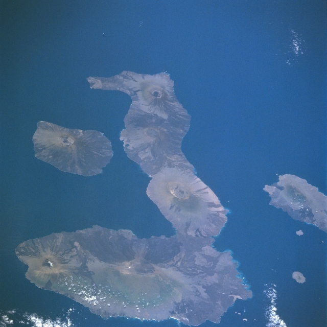 |
| NM22-723-069 Galapagos Islands, Ecuador Fall/Winter 1996 The Galapagos Islands comprise a volcanic archipelago with 21 major islands located approximately 600 miles (965 kilometers) west of Ecuador. Named for their endemic large turtles, these islands, although isolated from much of the world, are known internationally for their beauty and unique flora and fauna. Theirs is a fragile environment that the government of Ecuador is trying to protect. Isabela, the seahorse-shaped and largest island, is about 82 miles (132 kilometers) long. Wolf Volcano, the northernmost and tallest (5600 feet - 1707 meters), is situated almost exactly on the equator. Fernandina, the roughly oval-shaped island west of Isabela, is the youngest of the volcanic islands and is still geologically active, with a most recent eruption occurring in 1995. Notice that calderas have formed in the shield volcanoes that formed the islands. The variety of colors on the islands indicate different ages of lava flows and also illustrate the impact that the elevations of the volcanic cones have on rainfall patterns from one side of the islands to the other. Note the lack of "color" on the northwest slopes or sides of the volcanoes, indicating the "rain-shadow effect." |
| Images: | All Available Images Low-Resolution 273k |
|
| Mission: | NM22 |
|
| Roll - Frame: | 723 - 69 |
|
| Geographical Name: | GALAPAGOS ISLANDS |
|
| Features: | ISABELA, FERNANDINA, IS. |
|
| Center Lat x Lon: | 0.5S x 91W |
|
| Film Exposure: | N | N=Normal exposure, U=Under exposed, O=Over exposed, F=out of Focus |
| Percentage of Cloud Cover-CLDP: | 5 |
|
| Camera:: | HB |
|
| Camera Tilt: | LO | LO=Low Oblique, HO=High Oblique, NV=Near Vertical |
| Camera Focal Length: | 250 |
|
| Nadir to Photo Center Direction: | The direction from the nadir to the center point, N=North, S=South, E=East, W=West |
|
| Stereo?: | N | Y=Yes there is an adjacent picture of the same area, N=No there isn't |
| Orbit Number: | |
|
| Date: | 19961016 | YYYYMMDD |
| Time: | GMT HHMMSS |
|
| Nadir Lat: | N |
Latitude of suborbital point of spacecraft |
| Nadir Lon: | E |
Longitude of suborbital point of spacecraft |
| Sun Azimuth: | Clockwise angle in degrees from north to the sun measured at the nadir point |
|
| Space Craft Altitude: | nautical miles |
|
| Sun Elevation: | Angle in degrees between the horizon and the sun, measured at the nadir point |
|
| Land Views: | ISLAND, VOLCANO |
|
| Water Views: | |
|
| Atmosphere Views: | |
|
| Man Made Views: | |
|
| City Views: | |
|
Photo is not associated with any sequences | ||
| NASA Home Page |
JSC Home Page |
JSC Digital Image Collection |
Earth Science & Remote Sensing |
|
This service is provided by the International Space Station program and the JSC Earth Science & Remote Sensing Unit, ARES Division, Exploration Integration Science Directorate.

|