
Geographic Region: USA-UTAH
Feature: GREAT SALT LAKE & DESERT
|
Geographic Region: USA-UTAH Feature: GREAT SALT LAKE & DESERT |
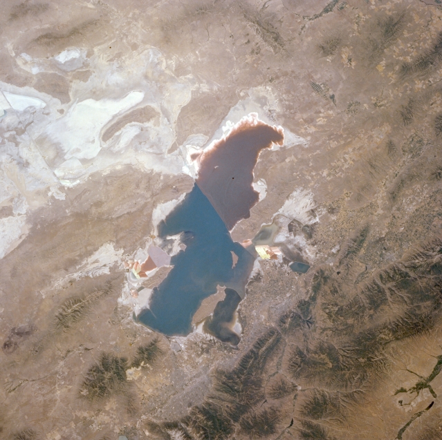 |
| NM21-775-075 Great Salt Lake and Great Salt Lake Desert, Utah, U.S.A. Winter 1995 and 1996 The Great Salt Lake, the largest salt lake in North America, is featured in this northwest-looking, low-oblique photograph. The lake normally covers 1000 square miles (2590 square kilometers) and averages 13 feet (4 meters) in depth, although it varies in size and depth seasonally and yearly. The lake is a remnant of prehistoric Lake Bonneville, which once covered an extensive area of the Great Basin. Apparent west of the Great Salt Lake are the white sands of the Great Salt Lake Desert and to the east is the rugged, forested Wasatch Range. Magnesium, chlorides, potash, and table salt are commercially extracted from the Great Salt Lake. |
| Images: | All Available Images Low-Resolution 331k |
|
| Mission: | NM21 |
|
| Roll - Frame: | 775 - 75 |
|
| Geographical Name: | USA-UTAH |
|
| Features: | GREAT SALT LAKE & DESERT |
|
| Center Lat x Lon: | 41.0N x 112.5W |
|
| Film Exposure: | N | N=Normal exposure, U=Under exposed, O=Over exposed, F=out of Focus |
| Percentage of Cloud Cover-CLDP: | 0 |
|
| Camera:: | HB |
|
| Camera Tilt: | LO | LO=Low Oblique, HO=High Oblique, NV=Near Vertical |
| Camera Focal Length: | 100 |
|
| Nadir to Photo Center Direction: | The direction from the nadir to the center point, N=North, S=South, E=East, W=West |
|
| Stereo?: | N | Y=Yes there is an adjacent picture of the same area, N=No there isn't |
| Orbit Number: | |
|
| Date: | 199607__ | YYYYMMDD |
| Time: | GMT HHMMSS |
|
| Nadir Lat: | N |
Latitude of suborbital point of spacecraft |
| Nadir Lon: | E |
Longitude of suborbital point of spacecraft |
| Sun Azimuth: | Clockwise angle in degrees from north to the sun measured at the nadir point |
|
| Space Craft Altitude: | nautical miles |
|
| Sun Elevation: | Angle in degrees between the horizon and the sun, measured at the nadir point |
|
| Land Views: | DESERT, MOUNTAIN |
|
| Water Views: | LAKE |
|
| Atmosphere Views: | |
|
| Man Made Views: | |
|
| City Views: | |
|
Photo is not associated with any sequences | ||
| NASA Home Page |
JSC Home Page |
JSC Digital Image Collection |
Earth Science & Remote Sensing |
|
This service is provided by the International Space Station program and the JSC Earth Science & Remote Sensing Unit, ARES Division, Exploration Integration Science Directorate.

|