
Geographic Region: UKRAINE
Feature: DANUBE RIVER DELTA, AGR.
|
Geographic Region: UKRAINE Feature: DANUBE RIVER DELTA, AGR. |
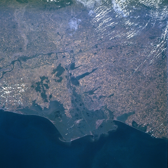 |
| NM21-774-009 Danube River Delta, Romania Spring/Summer 1996 The Danube River (dark meandering line- left middle) makes an abrupt course change near the center of this west-looking, synoptic view. The Danube then heads eastward draining the expansive marshlands of this unique western delta, eventually emptying into the western end of the Black Sea. Three major channels (only the straighter, middle channel is visible in this image) help drain this large wetland. The east-west section of the Danube River (vertical orientation in this image) shown in this scene forms the border between Romania (south of the river) and the southern tips of the Moldova (area north of river near center of image) and the Ukraine (north of the river, lower right quadrant). Even at this scale large, cultivated field patterns are observed throughout the scene. In particular notice the intensively cultivated landscape on the large island created by two branches of the Danube River (left middle). Refer to STS85-704-022, a color infrared image, to be able to effectively interpret the uniform, dark greenish-looking features. With the aid of the color infrared image, it is easier to discriminate land-water boundaries as well as vegetation versus water surfaces. Compare for example the lakes north of the river (Ukraine) with the elevated and forested (deeper reds on the color infrared image) region south of the river (Romania). It is also easier to discriminate vegetated areas in and around the delta versus the open water areas (lagoons, estuaries, lakes) along the coast. |
| Images: | Images: | NO IMAGES YET | |||
| Mission: | NM21 |
||||
| Roll - Frame: | 774 - 9 |
||||
| Geographical Name: | UKRAINE |
||||
| Features: | DANUBE RIVER DELTA, AGR. |
||||
| Center Lat x Lon: | 45.5N x 29.0E |
||||
| Film Exposure: | N | N=Normal exposure, U=Under exposed, O=Over exposed, F=out of Focus |
|||
| Percentage of Cloud Cover-CLDP: | 10 |
||||
| Camera:: | HB |
||||
| Camera Tilt: | 8 | LO=Low Oblique, HO=High Oblique, NV=Near Vertical |
|||
| Camera Focal Length: | 50 |
||||
| Nadir to Photo Center Direction: | NE | The direction from the nadir to the center point, N=North, S=South, E=East, W=West |
|||
| Stereo?: | Y | Y=Yes there is an adjacent picture of the same area, N=No there isn't |
|||
| Orbit Number: | 999 |
||||
| Date: | 19960721 | YYYYMMDD |
|||
| Time: | 073202 | GMT HHMMSS |
|||
| Nadir Lat: | 45.2N |
Latitude of suborbital point of spacecraft | |||
| Nadir Lon: | 28.6E |
Longitude of suborbital point of spacecraft | |||
| Sun Azimuth: | 113 | Clockwise angle in degrees from north to the sun measured at the nadir point |
|||
| Space Craft Altitude: | 207 | nautical miles |
|||
| Sun Elevation: | 49 | Angle in degrees between the horizon and the sun, measured at the nadir point |
|||
| Land Views: | COAST |
||||
| Water Views: | DELTA, RIVER |
||||
| Atmosphere Views: | |
||||
| Man Made Views: | AGRICULTURE |
||||
| City Views: | |
||||
Photo is not associated with any sequences | |||||
| NASA Home Page |
JSC Home Page |
JSC Digital Image Collection |
Earth Science & Remote Sensing |
|
This service is provided by the International Space Station program and the JSC Earth Science & Remote Sensing Unit, ARES Division, Exploration Integration Science Directorate.

|