
Geographic Region: USA-WYOMING
Feature: YELLOWSTONE L., DRAINAGE
|
Geographic Region: USA-WYOMING Feature: YELLOWSTONE L., DRAINAGE |
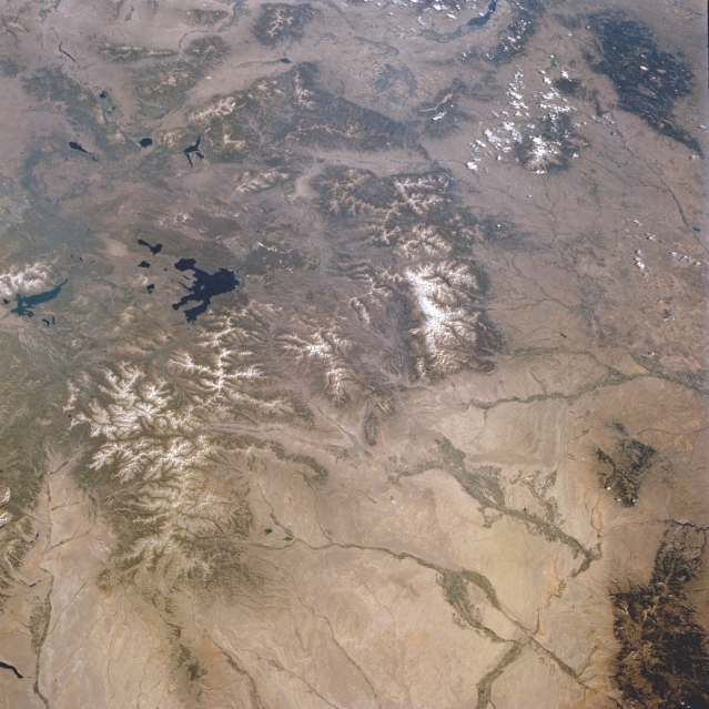 |
| NM21-774-082 Yellowstone National Park, Wyoming, U.S.A. Fall and Winter 1995 Featured in this panoramic northwest-looking photograph is the oldest national park in the world, Yellowstone National Park, which encompasses approximately 3500 square miles (9000 square kilometers) of high plateau country in northwest Wyoming. With approximately 300 geysers and 10 000 hot springs and steam vents, the park boasts the world's largest, most varied collection of geothermal phenomena. Viewing clockwise from the Teton Range and Jackson Lake, which lie south-southwest of Yellowstone Lake, are the Tobacco Root Mountains of Montana (top center); the Madison and Gallatin Ranges of southern Montana; the Little Belt Mountains of Montana (top right) with the Absaroka Mountains of Montana and northern Wyoming to their south; the Pryor Mountains of southern Montana; the northern Bighorn Mountains of north-central Wyoming (bottom right); and the lighter Bighorn Basin of Wyoming between the Bighorn Mountains and Yellowstone (bottom). Large fire scars from the extensive forest fires in 1988 are still visible as lighter green areas, especially along the western boundary of the park (line extending from upper left to top center). The fire scars are highlighted by snow in the winter scene NM22-727-24. |
| Images: | All Available Images Low-Resolution 342k |
|
| Mission: | NM21 |
|
| Roll - Frame: | 774 - 82 |
|
| Geographical Name: | USA-WYOMING |
|
| Features: | YELLOWSTONE L., DRAINAGE |
|
| Center Lat x Lon: | 44.5N x 109.5W |
|
| Film Exposure: | N | N=Normal exposure, U=Under exposed, O=Over exposed, F=out of Focus |
| Percentage of Cloud Cover-CLDP: | 5 |
|
| Camera:: | HB |
|
| Camera Tilt: | 13 | LO=Low Oblique, HO=High Oblique, NV=Near Vertical |
| Camera Focal Length: | 50 |
|
| Nadir to Photo Center Direction: | NW | The direction from the nadir to the center point, N=North, S=South, E=East, W=West |
| Stereo?: | N | Y=Yes there is an adjacent picture of the same area, N=No there isn't |
| Orbit Number: | 999 |
|
| Date: | 19960721 | YYYYMMDD |
| Time: | 164538 | GMT HHMMSS |
| Nadir Lat: | 43.9N |
Latitude of suborbital point of spacecraft |
| Nadir Lon: | 109W |
Longitude of suborbital point of spacecraft |
| Sun Azimuth: | 113 | Clockwise angle in degrees from north to the sun measured at the nadir point |
| Space Craft Altitude: | 207 | nautical miles |
| Sun Elevation: | 50 | Angle in degrees between the horizon and the sun, measured at the nadir point |
| Land Views: | CRATER, VOLCANO, MOUNTAIN, FOREST, BASIN |
|
| Water Views: | LAKE |
|
| Atmosphere Views: | |
|
| Man Made Views: | |
|
| City Views: | |
|
Photo is not associated with any sequences | ||
| NASA Home Page |
JSC Home Page |
JSC Digital Image Collection |
Earth Science & Remote Sensing |
|
This service is provided by the International Space Station program and the JSC Earth Science & Remote Sensing Unit, ARES Division, Exploration Integration Science Directorate.

|