
Geographic Region: USA-VIRGINIA
Feature: NORFOLK, NEWPORT NEWS
|
Geographic Region: USA-VIRGINIA Feature: NORFOLK, NEWPORT NEWS |
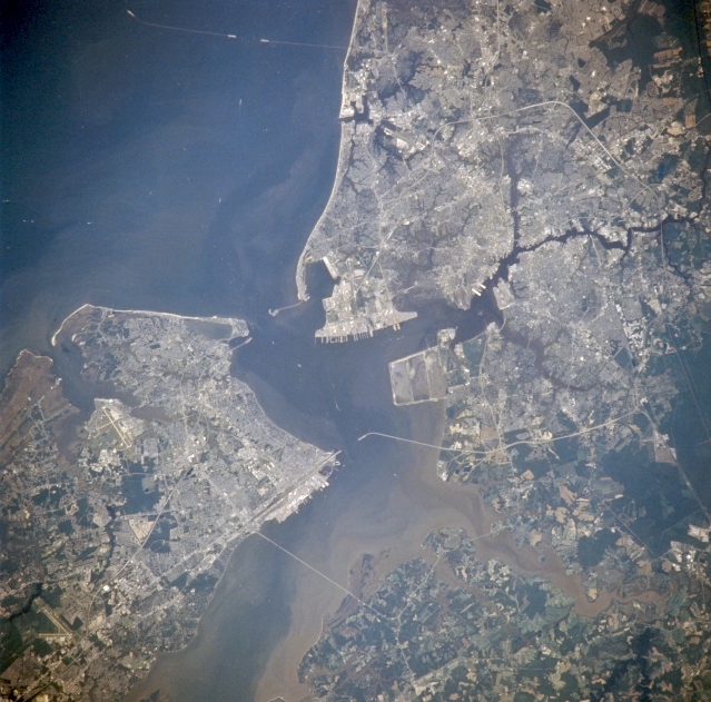 |
| NM21-774-049 Newport News, Hampton, Portsmouth, And Norfolk, Virginia, U.S.A. Winter-Summer 1996 The Norfolk metropolitan area can be seen in this near vertical view. Vast amounts of sediment can be seen flowing into Hampton Roads from the James (bottom center) and Nasemond (bottom right) Rivers. Chesapeake Bay is visible in the upper right portion of the image. Barely discernible is the Chesapeake Bay bridge and tunnel road that connects mainland Virginia with the southern tip of the Delmarva Peninsula (upper right). The city of Norfolk is located on the south side of Hampton Roads on the Elizabeth River. Norfolk is a major port of entry in the eastern United States, and a major commercial, industrial, shipping, and distribution center. With the cities of Portsmouth and Newport News, Norfolk forms the port of Hampton Roads, one of the best natural harbors in the world. Norfolk and Portsmouth form an extensive naval complex and operations base (the largest in the United States). It is here in Hampton Roads in 1862 that a major Civil War battle between the ironclad ships Merrimack and Monitor was fought. It is also here in Norfolk that one of the United States most famous Army generals, Douglas MacArthur is buried. |
| Images: | All Available Images Low-Resolution 347k |
|
| Mission: | NM21 |
|
| Roll - Frame: | 774 - 49 |
|
| Geographical Name: | USA-VIRGINIA |
|
| Features: | NORFOLK, NEWPORT NEWS |
|
| Center Lat x Lon: | 37.0N x 76.5W |
|
| Film Exposure: | N | N=Normal exposure, U=Under exposed, O=Over exposed, F=out of Focus |
| Percentage of Cloud Cover-CLDP: | 0 |
|
| Camera:: | HB |
|
| Camera Tilt: | 32 | LO=Low Oblique, HO=High Oblique, NV=Near Vertical |
| Camera Focal Length: | 250 |
|
| Nadir to Photo Center Direction: | S | The direction from the nadir to the center point, N=North, S=South, E=East, W=West |
| Stereo?: | Y | Y=Yes there is an adjacent picture of the same area, N=No there isn't |
| Orbit Number: | 999 |
|
| Date: | 19960721 | YYYYMMDD |
| Time: | 151539 | GMT HHMMSS |
| Nadir Lat: | 39.1N |
Latitude of suborbital point of spacecraft |
| Nadir Lon: | 76.8W |
Longitude of suborbital point of spacecraft |
| Sun Azimuth: | 117 | Clockwise angle in degrees from north to the sun measured at the nadir point |
| Space Craft Altitude: | 207 | nautical miles |
| Sun Elevation: | 58 | Angle in degrees between the horizon and the sun, measured at the nadir point |
| Land Views: | |
|
| Water Views: | BAY, RIVER, SEDIMENT |
|
| Atmosphere Views: | |
|
| Man Made Views: | URBAN AREA, AIRPORT |
|
| City Views: | HAMPTON, NORFOLK, PORTSMOUTH, NEWPORT NEWS |
|
Photo is not associated with any sequences | ||
| NASA Home Page |
JSC Home Page |
JSC Digital Image Collection |
Earth Science & Remote Sensing |
|
This service is provided by the International Space Station program and the JSC Earth Science & Remote Sensing Unit, ARES Division, Exploration Integration Science Directorate.

|