
Geographic Region: USA-PENNSYLVANIA
Feature: PITTSBURGH,MONONGAHELA R
|
Geographic Region: USA-PENNSYLVANIA Feature: PITTSBURGH,MONONGAHELA R |
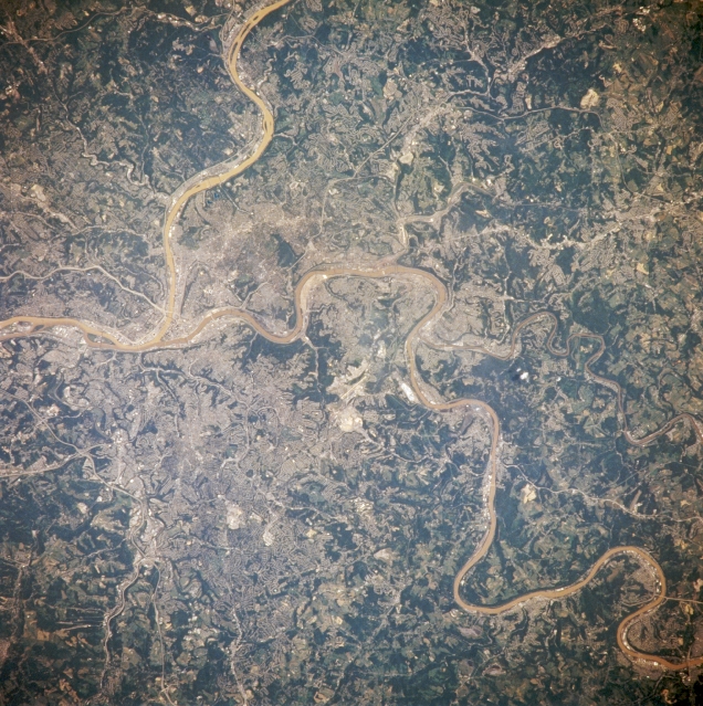 |
| NM21-774-044 Pittsburgh, Pennsylvania Spring-Summer 1996 The built-up metropolitan area that is the city of Pittsburgh is difficult to identify in this image because of the small scale, low spatial resolution, and in fact that most of the residential subdivisions contain vegetative cover that at least partially obscures the urban sprawl that surrounds the downtown core. Downtown Pittsburgh, or the central business district, is located at the apex of the influence of the southwest flowing Allegheny River and the northerly flowing Monongahela River (right center). These two rivers merge to become the Ohio River. Parts of several highway thoroughfares can be traced across the hilly terrain. The light colored, linear roadways include Interstate Highway 279 (left center); Interstate Highway 379 (lower left); Us highway 30 (left center); and state Highway 51 (towards upper left center). Residential development and highway orientation patterns have been greatly controlled by the local topography. The darker features of the image show the distribution of the more densely wooded terrain. |
| Images: | All Available Images Low-Resolution 408k |
|
| Mission: | NM21 |
|
| Roll - Frame: | 774 - 44 |
|
| Geographical Name: | USA-PENNSYLVANIA |
|
| Features: | PITTSBURGH,MONONGAHELA R |
|
| Center Lat x Lon: | 40.5N x 80W |
|
| Film Exposure: | N | N=Normal exposure, U=Under exposed, O=Over exposed, F=out of Focus |
| Percentage of Cloud Cover-CLDP: | 0 |
|
| Camera:: | HB |
|
| Camera Tilt: | 27 | LO=Low Oblique, HO=High Oblique, NV=Near Vertical |
| Camera Focal Length: | 250 |
|
| Nadir to Photo Center Direction: | SE | The direction from the nadir to the center point, N=North, S=South, E=East, W=West |
| Stereo?: | N | Y=Yes there is an adjacent picture of the same area, N=No there isn't |
| Orbit Number: | 999 |
|
| Date: | 19960721 | YYYYMMDD |
| Time: | 151430 | GMT HHMMSS |
| Nadir Lat: | 41.7N |
Latitude of suborbital point of spacecraft |
| Nadir Lon: | 81.3W |
Longitude of suborbital point of spacecraft |
| Sun Azimuth: | 116 | Clockwise angle in degrees from north to the sun measured at the nadir point |
| Space Craft Altitude: | 207 | nautical miles |
| Sun Elevation: | 54 | Angle in degrees between the horizon and the sun, measured at the nadir point |
| Land Views: | HILL |
|
| Water Views: | RIVER |
|
| Atmosphere Views: | |
|
| Man Made Views: | AIRPORT |
|
| City Views: | |
|
Photo is not associated with any sequences | ||
| NASA Home Page |
JSC Home Page |
JSC Digital Image Collection |
Earth Science & Remote Sensing |
|
This service is provided by the International Space Station program and the JSC Earth Science & Remote Sensing Unit, ARES Division, Exploration Integration Science Directorate.

|