
Geographic Region: ITALY
Feature: NAPLES, MT. VESUVIUS,BAY
|
Geographic Region: ITALY Feature: NAPLES, MT. VESUVIUS,BAY |
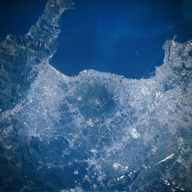 |
| NM21-771-075 Mt. Vesuvius Area, Italy Spring/Summer 1996 The oval-shaped crater of Mt. Vesuvius (circular feature in the center of the image) is encircled by the urban sprawl of Naples and many smaller urban areas along this section of the southwest coast of Italy. Naples, a major seaport and Italy's third largest city, is located along the north coast of the Gulf of Naples and is an arm of the Tyrrhenian Sea. Mt. Vesuvius' summit stands at 4200 feet (1281 meters) above sea level. It is the famous eruption of Vesuvius in 79 A.D. that destroyed the Roman cities of Pompeii and Ercolano. Mt. Vesuvius, now dormant, had its last major eruption in 1944. The steep calderas wall of Somma Volcano, an earlier stratovolcano, is visible several thousand feet north of the Vesuvius' crater. The darker-looking landscape shows the area of dense vegetation, while the lighter terrain is created by assorted human activities either in the form of cities, an extensive ground transportation network and agricultural operations. The rugged, mountainous Sorrento Peninsula (upper left corner) contrasts color wise with the more densely populated hilly scene that prevails over much of the terrain surrounding Mt. Vesuvius. |
| Images: | All Available Images Low-Resolution 377k |
|
| Mission: | NM21 |
|
| Roll - Frame: | 771 - 75 |
|
| Geographical Name: | ITALY |
|
| Features: | NAPLES, MT. VESUVIUS,BAY |
|
| Center Lat x Lon: | 41.0N x 14.5E |
|
| Film Exposure: | N | N=Normal exposure, U=Under exposed, O=Over exposed, F=out of Focus |
| Percentage of Cloud Cover-CLDP: | 0 |
|
| Camera:: | HB |
|
| Camera Tilt: | 44 | LO=Low Oblique, HO=High Oblique, NV=Near Vertical |
| Camera Focal Length: | 250 |
|
| Nadir to Photo Center Direction: | NE | The direction from the nadir to the center point, N=North, S=South, E=East, W=West |
| Stereo?: | Y | Y=Yes there is an adjacent picture of the same area, N=No there isn't |
| Orbit Number: | 999 |
|
| Date: | 19960710 | YYYYMMDD |
| Time: | 070449 | GMT HHMMSS |
| Nadir Lat: | 38.5N |
Latitude of suborbital point of spacecraft |
| Nadir Lon: | 12.4E |
Longitude of suborbital point of spacecraft |
| Sun Azimuth: | 88 | Clockwise angle in degrees from north to the sun measured at the nadir point |
| Space Craft Altitude: | 206 | nautical miles |
| Sun Elevation: | 34 | Angle in degrees between the horizon and the sun, measured at the nadir point |
| Land Views: | VOLCANO |
|
| Water Views: | GULF |
|
| Atmosphere Views: | |
|
| Man Made Views: | URBAN AREA |
|
| City Views: | |
|
Photo is not associated with any sequences | ||
| NASA Home Page |
JSC Home Page |
JSC Digital Image Collection |
Earth Science & Remote Sensing |
|
This service is provided by the International Space Station program and the JSC Earth Science & Remote Sensing Unit, ARES Division, Exploration Integration Science Directorate.

|