
Geographic Region: UKRAINE
Feature: DNIEPER RIVER, RES., AGR.
|
Geographic Region: UKRAINE Feature: DNIEPER RIVER, RES., AGR. |
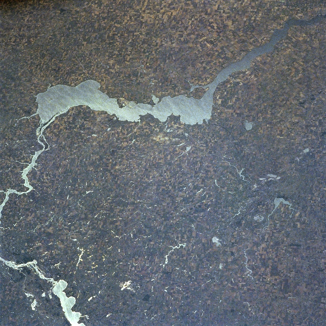 |
| NM21-769-018 Kakhovsk Reservoir, Ukraine Summer 1996 The southern portion of the 1430-mile (2300 km) long Dnepr (Dnieper) River and the Kakhovsk Reservoir are visible in this south-looking view. The Dnieper River rises in the Valdai Hills to the west of Moscow and flows generally southward emptying into the Black Sea. The river is navigable for most of its entire course. At the left center of the image and, is one of the Ukraine's leading industrial complexes, the city of Zaporozhye. Zaporozhye is home to one of the former USSR's largest hydroelectric plants. Near the right center of the image is the city of Krivoy Rog. Krivoy Rog is a major railroad center and industrial city located in the midst of one of the world's richest iron mining regions. The city is situated on the western edge of the Donets Basin, a major coal-producing region in the Ukraine. Winter wheat, corn, melons, and potatoes are grown in the agricultural region surrounding the Kakhovsk Reservoir. |
| Images: | All Available Images Low-Resolution 426k |
|
| Mission: | NM21 |
|
| Roll - Frame: | 769 - 18 |
|
| Geographical Name: | UKRAINE |
|
| Features: | DNIEPER RIVER, RES., AGR. |
|
| Center Lat x Lon: | 48.0N x 34.0E |
|
| Film Exposure: | N | N=Normal exposure, U=Under exposed, O=Over exposed, F=out of Focus |
| Percentage of Cloud Cover-CLDP: | 0 |
|
| Camera:: | HB |
|
| Camera Tilt: | LO | LO=Low Oblique, HO=High Oblique, NV=Near Vertical |
| Camera Focal Length: | 100 |
|
| Nadir to Photo Center Direction: | E | The direction from the nadir to the center point, N=North, S=South, E=East, W=West |
| Stereo?: | Y | Y=Yes there is an adjacent picture of the same area, N=No there isn't |
| Orbit Number: | |
|
| Date: | 19960709 | YYYYMMDD |
| Time: | GMT HHMMSS |
|
| Nadir Lat: | N |
Latitude of suborbital point of spacecraft |
| Nadir Lon: | E |
Longitude of suborbital point of spacecraft |
| Sun Azimuth: | Clockwise angle in degrees from north to the sun measured at the nadir point |
|
| Space Craft Altitude: | nautical miles |
|
| Sun Elevation: | Angle in degrees between the horizon and the sun, measured at the nadir point |
|
| Land Views: | PLAIN |
|
| Water Views: | RESERVOIR, RIVER |
|
| Atmosphere Views: | |
|
| Man Made Views: | DAM, AGRICULTURE, URBAN AREA |
|
| City Views: | |
|
Photo is not associated with any sequences | ||
| NASA Home Page |
JSC Home Page |
JSC Digital Image Collection |
Earth Science & Remote Sensing |
|
This service is provided by the International Space Station program and the JSC Earth Science & Remote Sensing Unit, ARES Division, Exploration Integration Science Directorate.

|