
Geographic Region: USA-WASHINGTON
Feature: SARATOGA PASS, EVERETT
|
Geographic Region: USA-WASHINGTON Feature: SARATOGA PASS, EVERETT |
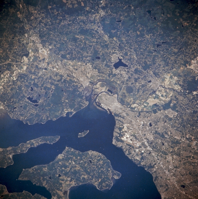 |
| NM21-768-005 Everett and Marysville, Washington, U.S.A. Winter 1995-1996 Everett, Washington, visible at the center of this east-northeast, low-oblique photograph, is located 28 miles (45 kilometers) north of Seattle at the mouth of the Snohomish River. Everett, a port of entry with a fine natural harbor, is an important lumber-shipping center and has pulp and paper mills. Other enterprises include fisheries, canneries, poultry-packing plants, shipyards, and airplane-manufacturing facilities. The Boeing Corporation facility is discernible south of Everett, just west of Interstate Highway 5, which is visible from near the center to the bottom right of the photograph. The small community of Marysville lies 5 miles (8 kilometers) north of Everett. Parts of narrow, pointed Camano Island and larger Whidbey Island are discernible in Puget Sound west of Everett. |
| Images: | All Available Images Low-Resolution 374k |
|
| Mission: | NM21 |
|
| Roll - Frame: | 768 - 5 |
|
| Geographical Name: | USA-WASHINGTON |
|
| Features: | SARATOGA PASS, EVERETT |
|
| Center Lat x Lon: | 48.0N x 122W |
|
| Film Exposure: | N | N=Normal exposure, U=Under exposed, O=Over exposed, F=out of Focus |
| Percentage of Cloud Cover-CLDP: | 0 |
|
| Camera:: | HB |
|
| Camera Tilt: | 55 | LO=Low Oblique, HO=High Oblique, NV=Near Vertical |
| Camera Focal Length: | 250 |
|
| Nadir to Photo Center Direction: | N | The direction from the nadir to the center point, N=North, S=South, E=East, W=West |
| Stereo?: | Y | Y=Yes there is an adjacent picture of the same area, N=No there isn't |
| Orbit Number: | 55 |
|
| Date: | 19960706 | YYYYMMDD |
| Time: | 175224 | GMT HHMMSS |
| Nadir Lat: | 43.4N |
Latitude of suborbital point of spacecraft |
| Nadir Lon: | 120.5W |
Longitude of suborbital point of spacecraft |
| Sun Azimuth: | 116 | Clockwise angle in degrees from north to the sun measured at the nadir point |
| Space Craft Altitude: | 207 | nautical miles |
| Sun Elevation: | 55 | Angle in degrees between the horizon and the sun, measured at the nadir point |
| Land Views: | ISLAND |
|
| Water Views: | |
|
| Atmosphere Views: | |
|
| Man Made Views: | URBAN AREA |
|
| City Views: | EVERETT |
|
Photo is not associated with any sequences | ||
| NASA Home Page |
JSC Home Page |
JSC Digital Image Collection |
Earth Science & Remote Sensing |
|
This service is provided by the International Space Station program and the JSC Earth Science & Remote Sensing Unit, ARES Division, Exploration Integration Science Directorate.

|