
Geographic Region: USA-WASHINGTON
Feature: TOTTEN INLET,AGR.,CITIES
|
Geographic Region: USA-WASHINGTON Feature: TOTTEN INLET,AGR.,CITIES |
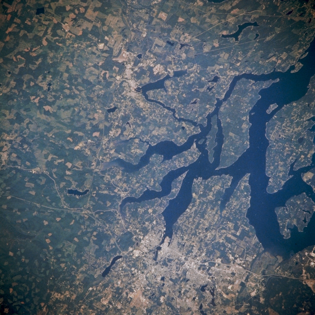 |
| NM21-768-011 Olympia and Southern Puget Sound, Washington, U.S.A. Winter 1995-1996 Olympia, the capital of Washington, is visible near the bottom center of this low-oblique, northwest-looking photograph. The city, home to canneries, breweries, and oyster fisheries, sits at the southern tip of Puget Sound on Budd Inlet 60 miles (97 kilometers) south-southwest of Seattle. Olympia is a center for manufacturing and shipping lumber products. It also has a thriving produce industry. Agricultural field patterns appear west and north of the city. Interstate Highway 5, the main transportation route through the city, connects Olympia with Tacoma and Seattle, Washington; Vancouver, British Columbia; and Portland, Oregon. Midway between the top center and the center of the photograph, the small town of Shelton is visible. Mason Lake is apparent at the top right of the photograph. |
| Images: | All Available Images Low-Resolution 380k |
|
| Mission: | NM21 |
|
| Roll - Frame: | 768 - 11 |
|
| Geographical Name: | USA-WASHINGTON |
|
| Features: | TOTTEN INLET,AGR.,CITIES |
|
| Center Lat x Lon: | 49.0N x 123W |
|
| Film Exposure: | N | N=Normal exposure, U=Under exposed, O=Over exposed, F=out of Focus |
| Percentage of Cloud Cover-CLDP: | 0 |
|
| Camera:: | HB |
|
| Camera Tilt: | LO | LO=Low Oblique, HO=High Oblique, NV=Near Vertical |
| Camera Focal Length: | 250 |
|
| Nadir to Photo Center Direction: | NW | The direction from the nadir to the center point, N=North, S=South, E=East, W=West |
| Stereo?: | Y | Y=Yes there is an adjacent picture of the same area, N=No there isn't |
| Orbit Number: | 55 |
|
| Date: | 19960706 | YYYYMMDD |
| Time: | 175235 | GMT HHMMSS |
| Nadir Lat: | 43.7N |
Latitude of suborbital point of spacecraft |
| Nadir Lon: | 119.7W |
Longitude of suborbital point of spacecraft |
| Sun Azimuth: | 117 | Clockwise angle in degrees from north to the sun measured at the nadir point |
| Space Craft Altitude: | 207 | nautical miles |
| Sun Elevation: | 56 | Angle in degrees between the horizon and the sun, measured at the nadir point |
| Land Views: | |
|
| Water Views: | |
|
| Atmosphere Views: | |
|
| Man Made Views: | URBAN AREA |
|
| City Views: | OLYMPIA |
|
Photo is not associated with any sequences | ||
| NASA Home Page |
JSC Home Page |
JSC Digital Image Collection |
Earth Science & Remote Sensing |
|
This service is provided by the International Space Station program and the JSC Earth Science & Remote Sensing Unit, ARES Division, Exploration Integration Science Directorate.

|