
Geographic Region: USA-NEW YORK
Feature: LONG ISLAND, BROOKHAVEN
|
Geographic Region: USA-NEW YORK Feature: LONG ISLAND, BROOKHAVEN |
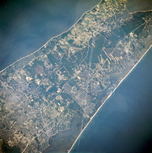 |
| NM21-766-071 Eastern Long Island, New York Spring-Summer 1996 A good portion of eastern Long Island can be seen in this northeast-looking view. The large circular area to the left of the center of the image is the Brookhaven National Laboratory. Long Island Sound, an arm of the Atlantic Ocean, covers the upper left quadrant of the image, and the Atlantic Ocean is visible in the lower right quadrant of the image. The beaches of the Fire Island National Seashore extend from the bottom center of the image terminating to the right of the center of the image. The runways of Suffolk County Airport are discernible in the upper right portion of the image. Major highways are visible traversing the area from west (bottom left) to east (upper right). Also noted is the thinning of urban areas to more agricultural and woodland land patterns from west to east on the image. |
| Images: | All Available Images Low-Resolution 372k |
|
| Mission: | NM21 |
|
| Roll - Frame: | 766 - 71 |
|
| Geographical Name: | USA-NEW YORK |
|
| Features: | LONG ISLAND, BROOKHAVEN |
|
| Center Lat x Lon: | 41.0N x 73W |
|
| Film Exposure: | N | N=Normal exposure, U=Under exposed, O=Over exposed, F=out of Focus |
| Percentage of Cloud Cover-CLDP: | 0 |
|
| Camera:: | HB |
|
| Camera Tilt: | LO | LO=Low Oblique, HO=High Oblique, NV=Near Vertical |
| Camera Focal Length: | 250 |
|
| Nadir to Photo Center Direction: | N | The direction from the nadir to the center point, N=North, S=South, E=East, W=West |
| Stereo?: | Y | Y=Yes there is an adjacent picture of the same area, N=No there isn't |
| Orbit Number: | |
|
| Date: | 19960705 | YYYYMMDD |
| Time: | GMT HHMMSS |
|
| Nadir Lat: | N |
Latitude of suborbital point of spacecraft |
| Nadir Lon: | E |
Longitude of suborbital point of spacecraft |
| Sun Azimuth: | Clockwise angle in degrees from north to the sun measured at the nadir point |
|
| Space Craft Altitude: | nautical miles |
|
| Sun Elevation: | Angle in degrees between the horizon and the sun, measured at the nadir point |
|
| Land Views: | COAST |
|
| Water Views: | BAY |
|
| Atmosphere Views: | |
|
| Man Made Views: | URBAN AREA, AIRPORT |
|
| City Views: | |
|
Photo is not associated with any sequences | ||
| NASA Home Page |
JSC Home Page |
JSC Digital Image Collection |
Earth Science & Remote Sensing |
|
This service is provided by the International Space Station program and the JSC Earth Science & Remote Sensing Unit, ARES Division, Exploration Integration Science Directorate.

|