
Geographic Region: USA-WISCONSIN
Feature: OSHKOSH,L. WINNEBAGO,AGR
|
Geographic Region: USA-WISCONSIN Feature: OSHKOSH,L. WINNEBAGO,AGR |
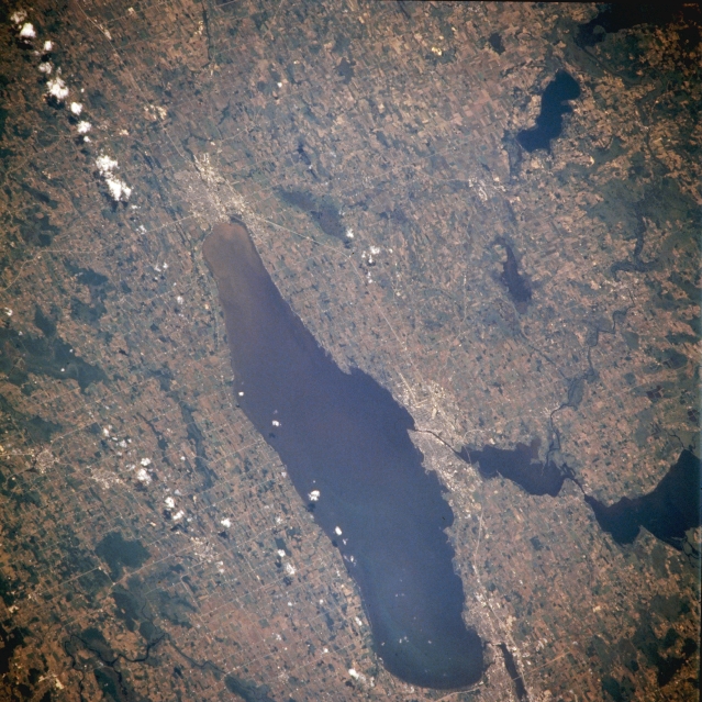 |
| NM21-765-050 Lake Winnebago, Wisconsin, U.S.A. Winter 1995-1996 Lake Winnebago, the largest freshwater lake in Wisconsin and a major recreation area, is featured in this southwest-looking, low-oblique photograph. More than 30 miles (48 kilometers) long and 10 miles (16 kilometers) at its widest point, Lake Winnebago comprises 215 square miles (557 square kilometers). The lake, part of a water route between the Great Lakes and the Mississippi River, is drained at its north end (bottom center of photograph) by the Fox River. Two major resort cities border the lake--Fond du Lac at the south end and Oshkosh on the west-central shore. Both cities are commercial and industrial centers. Other lakes visible include Butte des Morts and larger Poygan west-northwest of Oshkosh; west of Fond du Lac (upper right) are Rush, Green, and Puckaway. |
| Images: | All Available Images Low-Resolution 380k |
|
| Mission: | NM21 |
|
| Roll - Frame: | 765 - 50 |
|
| Geographical Name: | USA-WISCONSIN |
|
| Features: | OSHKOSH,L. WINNEBAGO,AGR |
|
| Center Lat x Lon: | 44.0N x 88.5W |
|
| Film Exposure: | N | N=Normal exposure, U=Under exposed, O=Over exposed, F=out of Focus |
| Percentage of Cloud Cover-CLDP: | 5 |
|
| Camera:: | HB |
|
| Camera Tilt: | 42 | LO=Low Oblique, HO=High Oblique, NV=Near Vertical |
| Camera Focal Length: | 250 |
|
| Nadir to Photo Center Direction: | W | The direction from the nadir to the center point, N=North, S=South, E=East, W=West |
| Stereo?: | Y | Y=Yes there is an adjacent picture of the same area, N=No there isn't |
| Orbit Number: | 999 |
|
| Date: | 19960703 | YYYYMMDD |
| Time: | 165307 | GMT HHMMSS |
| Nadir Lat: | 43.3N |
Latitude of suborbital point of spacecraft |
| Nadir Lon: | 85.5W |
Longitude of suborbital point of spacecraft |
| Sun Azimuth: | 147 | Clockwise angle in degrees from north to the sun measured at the nadir point |
| Space Craft Altitude: | 208 | nautical miles |
| Sun Elevation: | 67 | Angle in degrees between the horizon and the sun, measured at the nadir point |
| Land Views: | PLAIN |
|
| Water Views: | LAKE |
|
| Atmosphere Views: | |
|
| Man Made Views: | URBAN AREA, AGRICULTURE |
|
| City Views: | |
|
Photo is not associated with any sequences | ||
| NASA Home Page |
JSC Home Page |
JSC Digital Image Collection |
Earth Science & Remote Sensing |
|
This service is provided by the International Space Station program and the JSC Earth Science & Remote Sensing Unit, ARES Division, Exploration Integration Science Directorate.

|