
Geographic Region: USA-ILLINOIS
Feature: CHICAGO, STREETS, PORT
|
Geographic Region: USA-ILLINOIS Feature: CHICAGO, STREETS, PORT |
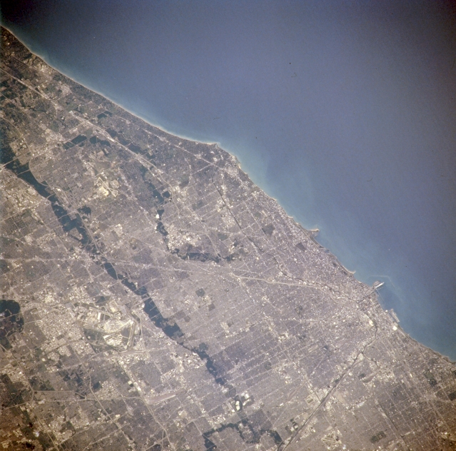 |
| NM21-765-044 Lake Michigan and Chicago, Illinois, U.S.A. Winter 1995-1996 Lake Michigan; central and northern Chicago; and the dark, north-south-trending Des Plaines River Valley are apparent in this north-northeast-looking, low-oblique photograph. Most of Chicago east of the Des Plaines River rests on the flat floor of ancestral Lakes Chicago and Nipissing--predecessors of Lake Michigan. Chicago, the nation's third largest city, is the commercial, financial, industrial, and cultural center for a vast region and a large midcontinental transportation and shipping point. The city covers more than 200 square miles (520 square kilometers) and extends more than 25 miles (40 kilometers) along Lake Michigan. Three airports are encompassed in this photograph--Chicago-O'Hare International (barely discernible, lower left), one of the busiest airports in the world; Glenview Naval Air Station between the Des Plaines and Chicago Rivers (above center); and Chicago Midway (barely discernible midway between bottom center and bottom right). (Refer to NM21-765-043 for a photograph of south Chicago.) |
| Images: | All Available Images Low-Resolution 337k |
|
| Mission: | NM21 |
|
| Roll - Frame: | 765 - 44 |
|
| Geographical Name: | USA-ILLINOIS |
|
| Features: | CHICAGO, STREETS, PORT |
|
| Center Lat x Lon: | 42.0N x 88W |
|
| Film Exposure: | N | N=Normal exposure, U=Under exposed, O=Over exposed, F=out of Focus |
| Percentage of Cloud Cover-CLDP: | 0 |
|
| Camera:: | HB |
|
| Camera Tilt: | 12 | LO=Low Oblique, HO=High Oblique, NV=Near Vertical |
| Camera Focal Length: | 250 |
|
| Nadir to Photo Center Direction: | E | The direction from the nadir to the center point, N=North, S=South, E=East, W=West |
| Stereo?: | Y | Y=Yes there is an adjacent picture of the same area, N=No there isn't |
| Orbit Number: | 999 |
|
| Date: | 19960703 | YYYYMMDD |
| Time: | 165221 | GMT HHMMSS |
| Nadir Lat: | 41.7N |
Latitude of suborbital point of spacecraft |
| Nadir Lon: | 88.7W |
Longitude of suborbital point of spacecraft |
| Sun Azimuth: | 138 | Clockwise angle in degrees from north to the sun measured at the nadir point |
| Space Craft Altitude: | 208 | nautical miles |
| Sun Elevation: | 67 | Angle in degrees between the horizon and the sun, measured at the nadir point |
| Land Views: | |
|
| Water Views: | LAKE |
|
| Atmosphere Views: | |
|
| Man Made Views: | URBAN AREA, AIRPORT |
|
| City Views: | CHICAGO |
|
Photo is not associated with any sequences | ||
| NASA Home Page |
JSC Home Page |
JSC Digital Image Collection |
Earth Science & Remote Sensing |
|
This service is provided by the International Space Station program and the JSC Earth Science & Remote Sensing Unit, ARES Division, Exploration Integration Science Directorate.

|