
Geographic Region: USA-ILLINOIS
Feature: MISSISSIPPI R.,KEOKUK IA
|
Geographic Region: USA-ILLINOIS Feature: MISSISSIPPI R.,KEOKUK IA |
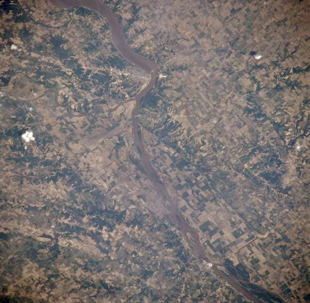 |
| NM21-765-033 Mississippi River and Keokuk, Iowa, U.S.A. Winter 1995-1996 The muddy Mississippi River passes Keokuk in this northeast-looking, low-oblique photograph. Keokuk, named for a Sac Indian chief who is buried at a city park, is situated in extreme southeast Iowa on the western bank of the Mississippi River at the foot of the Des Moines River. Lake Keokuk and its gravity dam, which was completed in 1913, furnish hydroelectric power for Keokuk's many industries, which include food processing and packaging and metal products. |
| Images: | All Available Images Low-Resolution 362k |
|
| Mission: | NM21 |
|
| Roll - Frame: | 765 - 33 |
|
| Geographical Name: | USA-ILLINOIS |
|
| Features: | MISSISSIPPI R.,KEOKUK IA |
|
| Center Lat x Lon: | 40.0N x 91.5W |
|
| Film Exposure: | N | N=Normal exposure, U=Under exposed, O=Over exposed, F=out of Focus |
| Percentage of Cloud Cover-CLDP: | 0 |
|
| Camera:: | HB |
|
| Camera Tilt: | 5 | LO=Low Oblique, HO=High Oblique, NV=Near Vertical |
| Camera Focal Length: | 250 |
|
| Nadir to Photo Center Direction: | E | The direction from the nadir to the center point, N=North, S=South, E=East, W=West |
| Stereo?: | Y | Y=Yes there is an adjacent picture of the same area, N=No there isn't |
| Orbit Number: | 999 |
|
| Date: | 19960703 | YYYYMMDD |
| Time: | 165134 | GMT HHMMSS |
| Nadir Lat: | 39.9N |
Latitude of suborbital point of spacecraft |
| Nadir Lon: | 91.8W |
Longitude of suborbital point of spacecraft |
| Sun Azimuth: | 129 | Clockwise angle in degrees from north to the sun measured at the nadir point |
| Space Craft Altitude: | 208 | nautical miles |
| Sun Elevation: | 66 | Angle in degrees between the horizon and the sun, measured at the nadir point |
| Land Views: | |
|
| Water Views: | RIVER |
|
| Atmosphere Views: | |
|
| Man Made Views: | AGRICULTURE, URBAN AREA |
|
| City Views: | |
|
Photo is not associated with any sequences | ||
| NASA Home Page |
JSC Home Page |
JSC Digital Image Collection |
Earth Science & Remote Sensing |
|
This service is provided by the International Space Station program and the JSC Earth Science & Remote Sensing Unit, ARES Division, Exploration Integration Science Directorate.

|