
Geographic Region: USA-MISSOURI
Feature: HANNIBAL MO., QUINCY IL.
|
Geographic Region: USA-MISSOURI Feature: HANNIBAL MO., QUINCY IL. |
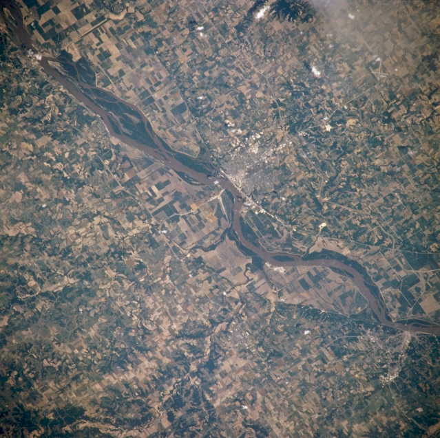 |
| NM21-765-031 Mississippi River and Quincy, Illinois, U.S.A. Winter 1995-1996 Featured in this northeast-looking, low-oblique photograph is the portion of the Mississippi River between Canton and Hannibal, Missouri. Visible are the river's floodplain and numerous agricultural field patterns, the area devastated by the floods of the spring and summer of 1993. Atop a bluff on the eastern shore of the river is Quincy, Illinois (near center), a trade, industrial, and distribution center in a grain and livestock producing area. The city has a good harbor and was an important river port in the mid-19th century. Hannibal, Missouri (near bottom right), the boyhood home of author Mark Twain, sits on the western shore of the Mississippi River. |
| Images: | All Available Images Low-Resolution 393k |
|
| Mission: | NM21 |
|
| Roll - Frame: | 765 - 31 |
|
| Geographical Name: | USA-MISSOURI |
|
| Features: | HANNIBAL MO., QUINCY IL. |
|
| Center Lat x Lon: | 40.0N x 91.5W |
|
| Film Exposure: | N | N=Normal exposure, U=Under exposed, O=Over exposed, F=out of Focus |
| Percentage of Cloud Cover-CLDP: | 5 |
|
| Camera:: | HB |
|
| Camera Tilt: | 12 | LO=Low Oblique, HO=High Oblique, NV=Near Vertical |
| Camera Focal Length: | 250 |
|
| Nadir to Photo Center Direction: | E | The direction from the nadir to the center point, N=North, S=South, E=East, W=West |
| Stereo?: | Y | Y=Yes there is an adjacent picture of the same area, N=No there isn't |
| Orbit Number: | 999 |
|
| Date: | 19960703 | YYYYMMDD |
| Time: | 165128 | GMT HHMMSS |
| Nadir Lat: | 39.7N |
Latitude of suborbital point of spacecraft |
| Nadir Lon: | 92.2W |
Longitude of suborbital point of spacecraft |
| Sun Azimuth: | 128 | Clockwise angle in degrees from north to the sun measured at the nadir point |
| Space Craft Altitude: | 208 | nautical miles |
| Sun Elevation: | 66 | Angle in degrees between the horizon and the sun, measured at the nadir point |
| Land Views: | VALLEY |
|
| Water Views: | RIVER |
|
| Atmosphere Views: | |
|
| Man Made Views: | AGRICULTURE, URBAN AREA |
|
| City Views: | |
|
Photo is not associated with any sequences | ||
| NASA Home Page |
JSC Home Page |
JSC Digital Image Collection |
Earth Science & Remote Sensing |
|
This service is provided by the International Space Station program and the JSC Earth Science & Remote Sensing Unit, ARES Division, Exploration Integration Science Directorate.

|