
Geographic Region: USA-WISCONSIN
Feature: GREEN BAY,FOX RIVER,AGR.
|
Geographic Region: USA-WISCONSIN Feature: GREEN BAY,FOX RIVER,AGR. |
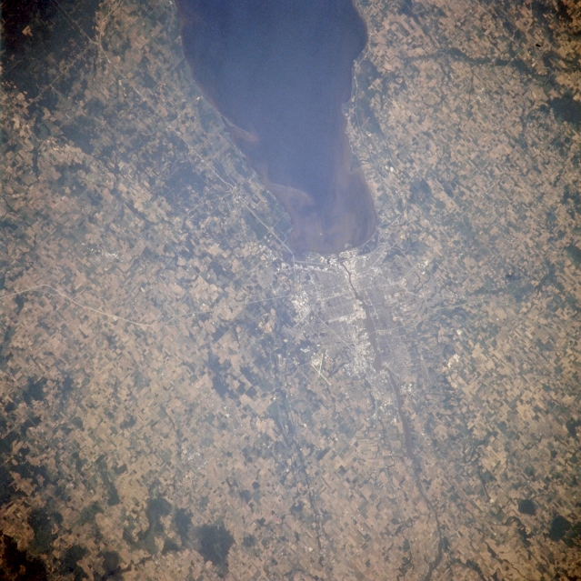 |
| NM21-763-037 Fox River and Green Bay, Wisconsin, U.S.A. Winter 1995-1996 Featured in this east-southeast-looking, low-oblique photograph is the city of Green Bay at the mouth of the Fox River, which empties into the southern end of Green Bay, an arm of Lake Michigan. Green Bay, the oldest permanent settlement in Wisconsin and one of the best harbors on the Great Lakes, is a wholesale, industrial, and railroad center for northeast Wisconsin. Apparent in the southern end of Green Bay is sediment from the Fox River, which drains Lake Winnebago to the south (not visible). Through the efforts of many communities, the Fox River, which suffered in the past from industrial pollution, has made great strides toward becoming pollution free. The runways of Austin Straubel Airport are visible (near the center of the photograph). |
| Images: | All Available Images Low-Resolution 355k |
|
| Mission: | NM21 |
|
| Roll - Frame: | 763 - 37 |
|
| Geographical Name: | USA-WISCONSIN |
|
| Features: | GREEN BAY,FOX RIVER,AGR. |
|
| Center Lat x Lon: | 44.5N x 88W |
|
| Film Exposure: | N | N=Normal exposure, U=Under exposed, O=Over exposed, F=out of Focus |
| Percentage of Cloud Cover-CLDP: | 0 |
|
| Camera:: | HB |
|
| Camera Tilt: | 38 | LO=Low Oblique, HO=High Oblique, NV=Near Vertical |
| Camera Focal Length: | 250 |
|
| Nadir to Photo Center Direction: | E | The direction from the nadir to the center point, N=North, S=South, E=East, W=West |
| Stereo?: | N | Y=Yes there is an adjacent picture of the same area, N=No there isn't |
| Orbit Number: | 999 |
|
| Date: | 19960629 | YYYYMMDD |
| Time: | 190049 | GMT HHMMSS |
| Nadir Lat: | 44.6N |
Latitude of suborbital point of spacecraft |
| Nadir Lon: | 90.7W |
Longitude of suborbital point of spacecraft |
| Sun Azimuth: | 212 | Clockwise angle in degrees from north to the sun measured at the nadir point |
| Space Craft Altitude: | 208 | nautical miles |
| Sun Elevation: | 66 | Angle in degrees between the horizon and the sun, measured at the nadir point |
| Land Views: | |
|
| Water Views: | BAY, RIVER |
|
| Atmosphere Views: | |
|
| Man Made Views: | URBAN AREA, AGRICULTURE |
|
| City Views: | GREEN BAY |
|
Photo is not associated with any sequences | ||
| NASA Home Page |
JSC Home Page |
JSC Digital Image Collection |
Earth Science & Remote Sensing |
|
This service is provided by the International Space Station program and the JSC Earth Science & Remote Sensing Unit, ARES Division, Exploration Integration Science Directorate.

|