
Geographic Region: USA-IOWA
Feature: DES MOINES,R.,RES.,ROADS
|
Geographic Region: USA-IOWA Feature: DES MOINES,R.,RES.,ROADS |
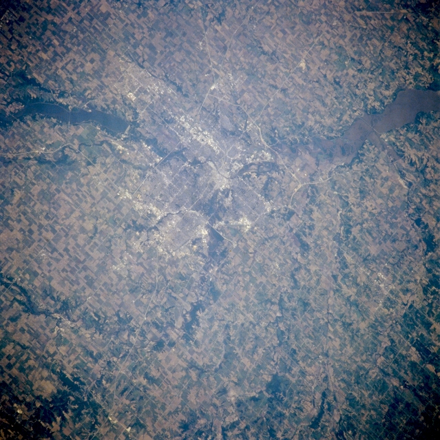 |
| NM21-763-035 Des Moines, Iowa, U.S.A. Winter 1995-1996 Surrounded by agricultural field patterns in this northeast-looking, low-oblique photograph is Des Moines, the capital of Iowa, the state with 25 percent of the highest grade topsoil in the United States. More than 90 percent of Iowa is devoted to agriculture; only California ranks ahead of Iowa in cash farm income. Des Moines, situated at the junction of the Des Moines and Raccoon Rivers, is an important industrial and transportation center in the heart of the U.S. corn belt and coal mining region and is the location of the home offices of numerous insurance companies. Des Moines, home of the first U. S. Women's Army Corp Training Center that opened in 1942, was devastated by floods in 1954 and 1993. Dams and reservoirs built on the Des Moines River after 1954 provide flood control relief. Two reservoirs are visible--Saylorville north-northwest of the city and sediment-laden Red Rock to the east-southeast. |
| Images: | All Available Images Low-Resolution 387k |
|
| Mission: | NM21 |
|
| Roll - Frame: | 763 - 35 |
|
| Geographical Name: | USA-IOWA |
|
| Features: | DES MOINES,R.,RES.,ROADS |
|
| Center Lat x Lon: | 41.5N x 94W |
|
| Film Exposure: | N | N=Normal exposure, U=Under exposed, O=Over exposed, F=out of Focus |
| Percentage of Cloud Cover-CLDP: | 0 |
|
| Camera:: | HB |
|
| Camera Tilt: | 38 | LO=Low Oblique, HO=High Oblique, NV=Near Vertical |
| Camera Focal Length: | 250 |
|
| Nadir to Photo Center Direction: | E | The direction from the nadir to the center point, N=North, S=South, E=East, W=West |
| Stereo?: | N | Y=Yes there is an adjacent picture of the same area, N=No there isn't |
| Orbit Number: | 999 |
|
| Date: | 19960629 | YYYYMMDD |
| Time: | 185925 | GMT HHMMSS |
| Nadir Lat: | 41.8N |
Latitude of suborbital point of spacecraft |
| Nadir Lon: | 96.7W |
Longitude of suborbital point of spacecraft |
| Sun Azimuth: | 200 | Clockwise angle in degrees from north to the sun measured at the nadir point |
| Space Craft Altitude: | 208 | nautical miles |
| Sun Elevation: | 71 | Angle in degrees between the horizon and the sun, measured at the nadir point |
| Land Views: | PLAIN |
|
| Water Views: | LAKE |
|
| Atmosphere Views: | |
|
| Man Made Views: | URBAN AREA, AGRICULTURE |
|
| City Views: | DES MOINES |
|
Photo is not associated with any sequences | ||
| NASA Home Page |
JSC Home Page |
JSC Digital Image Collection |
Earth Science & Remote Sensing |
|
This service is provided by the International Space Station program and the JSC Earth Science & Remote Sensing Unit, ARES Division, Exploration Integration Science Directorate.

|