
Geographic Region: USA-NEBRASKA
Feature: N. PLATTE R., RES.,DUNES
|
Geographic Region: USA-NEBRASKA Feature: N. PLATTE R., RES.,DUNES |
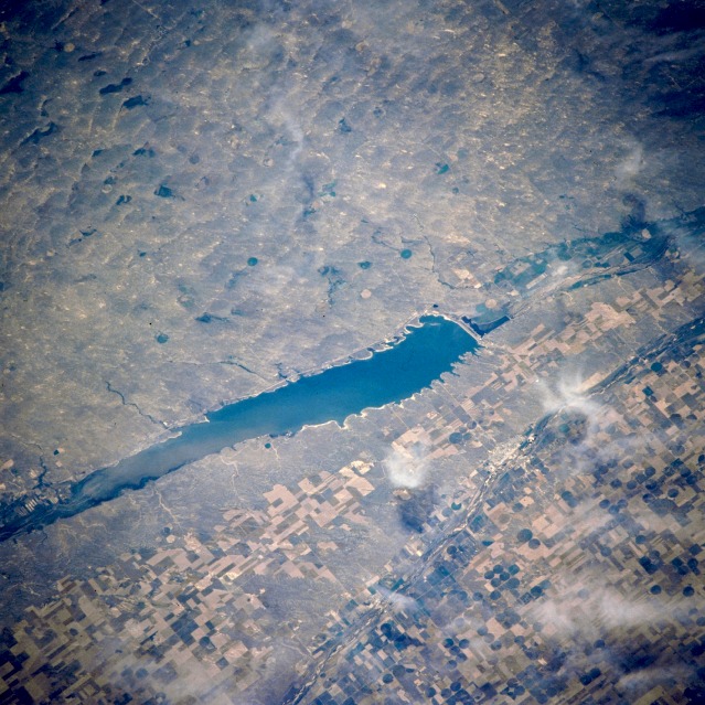 |
| NM21-763-030 Lake C. W. McConaughy and Sand Hills, Nebraska, U.S.A. Winter 1995-1996 Featured in this northeast-looking, low-oblique photograph are the Kingsley Dam and Lake C. W. McConaughy on the North Platte River, which separates the agricultural south from the Sand Hills to the north. The lake provides water for public water systems, irrigation, and recreation. The Sand Hills, formed during the ice ages and covering 20 000 square miles (50 000 square kilometers), is the largest sand dune complex in the Western Hemisphere. Most are transverse dunes--some as high as 300 feet (90 meters) and 10 miles (16 kilometers) long. Many Sand Hills valleys distant from major streams contain wet meadows or small, shallow lakes, some of which rise and fall with the fluctuating water table. The flat valleys of both the North Platte River and the South Platte River (bottom center) were followed by pioneers moving west from the eastern United States. The first transcontinental railroad also followed this route. |
| Images: | All Available Images Low-Resolution 153k |
|
| Mission: | NM21 |
|
| Roll - Frame: | 763 - 30 |
|
| Geographical Name: | USA-NEBRASKA |
|
| Features: | N. PLATTE R., RES.,DUNES |
|
| Center Lat x Lon: | 41.5N x 102W |
|
| Film Exposure: | N | N=Normal exposure, U=Under exposed, O=Over exposed, F=out of Focus |
| Percentage of Cloud Cover-CLDP: | 20 |
|
| Camera:: | HB |
|
| Camera Tilt: | 38 | LO=Low Oblique, HO=High Oblique, NV=Near Vertical |
| Camera Focal Length: | 250 |
|
| Nadir to Photo Center Direction: | N | The direction from the nadir to the center point, N=North, S=South, E=East, W=West |
| Stereo?: | Y | Y=Yes there is an adjacent picture of the same area, N=No there isn't |
| Orbit Number: | 999 |
|
| Date: | 19960629 | YYYYMMDD |
| Time: | 185805 | GMT HHMMSS |
| Nadir Lat: | 38.8N |
Latitude of suborbital point of spacecraft |
| Nadir Lon: | 102W |
Longitude of suborbital point of spacecraft |
| Sun Azimuth: | 186 | Clockwise angle in degrees from north to the sun measured at the nadir point |
| Space Craft Altitude: | 209 | nautical miles |
| Sun Elevation: | 75 | Angle in degrees between the horizon and the sun, measured at the nadir point |
| Land Views: | DUNE, PLAIN |
|
| Water Views: | RIVER, LAKE |
|
| Atmosphere Views: | |
|
| Man Made Views: | AGRICULTURE |
|
| City Views: | |
|
Photo is not associated with any sequences | ||
| NASA Home Page |
JSC Home Page |
JSC Digital Image Collection |
Earth Science & Remote Sensing |
|
This service is provided by the International Space Station program and the JSC Earth Science & Remote Sensing Unit, ARES Division, Exploration Integration Science Directorate.

|