
Geographic Region: UZBEKISTAN
Feature: ARAL SEA, SUNGLINT
|
Geographic Region: UZBEKISTAN Feature: ARAL SEA, SUNGLINT |
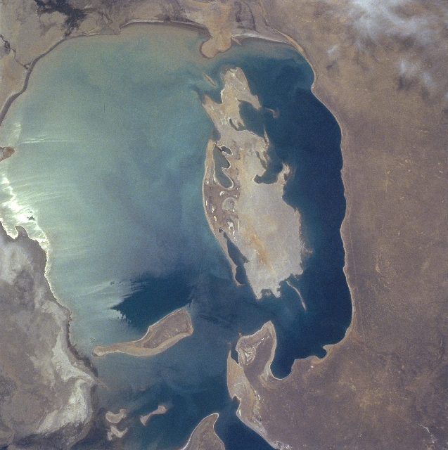 |
| NM21-746-024 Aral Sea, Kazakhstan and Uzbekistan Spring-Summer 1996 As a result of the shrinking size (due to the loss of recharge water and a high rate of evaporation) of the Aral Sea, both Vozrozhdeniya Island (irregular-shaped, large) and Barsakel'mes Island (elongated, smaller) are gaining more surface area, which was formerly the sea floor. If sea level continues to drop the Aral Sea could continue to become more compartmentalized (the Little Aral Sea - not in this image - has already been created north of the Aral Sea). As more of the sea bottom is exposed and the islands and peninsulas become connected land, the existing Aral Sea could become several separate bodies of water - forming new lakes. Since much less fresh water now enters the sea (most water diverted for agriculture), salinity levels have steadily increased since 1960. The bright area in the eastern (left) half of the sea is caused by the sun's reflection off of the water's surface, a phenomenon known as sunglint or sun glitter. A pipeline right of way and a road (thin, light-colored, lined feature) parallel the west side of the sea. |
| Images: | All Available Images Low-Resolution 335k |
|
| Mission: | NM21 |
|
| Roll - Frame: | 746 - 24 |
|
| Geographical Name: | UZBEKISTAN |
|
| Features: | ARAL SEA, SUNGLINT |
|
| Center Lat x Lon: | 44.5N x 59.5E |
|
| Film Exposure: | N | N=Normal exposure, U=Under exposed, O=Over exposed, F=out of Focus |
| Percentage of Cloud Cover-CLDP: | 5 |
|
| Camera:: | HB |
|
| Camera Tilt: | 53 | LO=Low Oblique, HO=High Oblique, NV=Near Vertical |
| Camera Focal Length: | 100 |
|
| Nadir to Photo Center Direction: | E | The direction from the nadir to the center point, N=North, S=South, E=East, W=West |
| Stereo?: | Y | Y=Yes there is an adjacent picture of the same area, N=No there isn't |
| Orbit Number: | 999 |
|
| Date: | 19960514 | YYYYMMDD |
| Time: | 084801 | GMT HHMMSS |
| Nadir Lat: | 46.2N |
Latitude of suborbital point of spacecraft |
| Nadir Lon: | 55.1E |
Longitude of suborbital point of spacecraft |
| Sun Azimuth: | 196 | Clockwise angle in degrees from north to the sun measured at the nadir point |
| Space Craft Altitude: | 210 | nautical miles |
| Sun Elevation: | 62 | Angle in degrees between the horizon and the sun, measured at the nadir point |
| Land Views: | ISLAND |
|
| Water Views: | SEA, SUNGLINT |
|
| Atmosphere Views: | |
|
| Man Made Views: | |
|
| City Views: | |
|
Photo is not associated with any sequences | ||
| NASA Home Page |
JSC Home Page |
JSC Digital Image Collection |
Earth Science & Remote Sensing |
|
This service is provided by the International Space Station program and the JSC Earth Science & Remote Sensing Unit, ARES Division, Exploration Integration Science Directorate.

|