
Geographic Region: KAZAKHSTAN
Feature: ARAL SEA, PASKEVICHA BAY
|
Geographic Region: KAZAKHSTAN Feature: ARAL SEA, PASKEVICHA BAY |
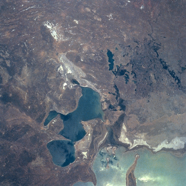 |
| NM21-735-046 Little Aral Sea, Kazakhstan Spring-Summer 1996 The subdued tan and brown colors of the desert terrain around the Little Aral Sea (darker feature near bottom center), formerly known as the northern basin of the Aral Sea, tends to accentuate the stressful environmental conditions that presently exist in southwest Kazakhstan. The sizeable, light-colored area (bottom right corner) is the northeast corner of the Aral Sea. The thin, dark, meandering feature (upper right corner) is the main channel of the Syr Darya as it drains westward before the river diffuses into a broad delta (darker landscape near right edge of image) of many canals and streams. The dark features within the vicinity of the delta show the location and size of small lakes within the structure of the Syr Darya Delta. The highly reflective (whiter-looking features) areas are salt flats (dry lake beds) that are scattered throughout this arid landscape. Because of the rapid drop in sea level in the Aral Sea since 1960, the once thriving fishing port of Aralsk is now 60 miles (97 km) from the shore of the Little Aral Sea (northeast corner of the sea). |
| Images: | All Available Images Low-Resolution 388k |
|
| Mission: | NM21 |
|
| Roll - Frame: | 735 - 46 |
|
| Geographical Name: | KAZAKHSTAN |
|
| Features: | ARAL SEA, PASKEVICHA BAY |
|
| Center Lat x Lon: | 46.5N x 61.0E |
|
| Film Exposure: | N | N=Normal exposure, U=Under exposed, O=Over exposed, F=out of Focus |
| Percentage of Cloud Cover-CLDP: | 0 |
|
| Camera:: | HB |
|
| Camera Tilt: | 17 | LO=Low Oblique, HO=High Oblique, NV=Near Vertical |
| Camera Focal Length: | 250 |
|
| Nadir to Photo Center Direction: | S | The direction from the nadir to the center point, N=North, S=South, E=East, W=West |
| Stereo?: | N | Y=Yes there is an adjacent picture of the same area, N=No there isn't |
| Orbit Number: | 999 |
|
| Date: | 19960502 | YYYYMMDD |
| Time: | 084428 | GMT HHMMSS |
| Nadir Lat: | 47.5N |
Latitude of suborbital point of spacecraft |
| Nadir Lon: | 61.4E |
Longitude of suborbital point of spacecraft |
| Sun Azimuth: | 204 | Clockwise angle in degrees from north to the sun measured at the nadir point |
| Space Craft Altitude: | 210 | nautical miles |
| Sun Elevation: | 56 | Angle in degrees between the horizon and the sun, measured at the nadir point |
| Land Views: | DESERT |
|
| Water Views: | SEA |
|
| Atmosphere Views: | |
|
| Man Made Views: | |
|
| City Views: | |
|
Photo is not associated with any sequences | ||
| NASA Home Page |
JSC Home Page |
JSC Digital Image Collection |
Earth Science & Remote Sensing |
|
This service is provided by the International Space Station program and the JSC Earth Science & Remote Sensing Unit, ARES Division, Exploration Integration Science Directorate.

|