
Geographic Region: USA-MONTANA
Feature: CANYON FERRY LAKE, AGR.
|
Geographic Region: USA-MONTANA Feature: CANYON FERRY LAKE, AGR. |
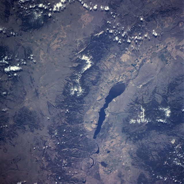 |
| NASA7-723-048 Big Belt Mountains, Montana Spring, 1998 Traversing the image from near the bottom center to almost the upper right center, the northwest/southeast trending Big Belt Mountains can be seen in this southeast-looking low-oblique view. The Big Belt Mountains are a part of the Rocky Mountains. These mountains are forested and very rugged with numerous canyons. Mount Edith at 9504 feet (2899 meters) is the highest peak in the mountain range and is located slightly above the center of the image. West of the Big Belt Mountains is the Upper Missouri River Valley and Canyon Ferry Lake. To the west of Canyon Ferry Lake are the Elkhorn Mountains. Barely discernible midway between the bottom center and the right center of the image is the capitol city of Montana, Helena. Referred to as "The Queen City of the Rockies", Helena is located at the southern end of the Helena Valley approximately 20 miles (32 km) west of the northern part of Canyon Ferry Lake. |
| Images: | All Available Images Low-Resolution 365k |
|
| Mission: | NASA7 |
|
| Roll - Frame: | 723 - 48 |
|
| Geographical Name: | USA-MONTANA |
|
| Features: | CANYON FERRY LAKE, AGR. |
|
| Center Lat x Lon: | 46.5N x 111.5W |
|
| Film Exposure: | N | N=Normal exposure, U=Under exposed, O=Over exposed, F=out of Focus |
| Percentage of Cloud Cover-CLDP: | 5 |
|
| Camera:: | HB |
|
| Camera Tilt: | LO | LO=Low Oblique, HO=High Oblique, NV=Near Vertical |
| Camera Focal Length: | 100 |
|
| Nadir to Photo Center Direction: | The direction from the nadir to the center point, N=North, S=South, E=East, W=West |
|
| Stereo?: | Y | Y=Yes there is an adjacent picture of the same area, N=No there isn't |
| Orbit Number: | |
|
| Date: | 19980510 | YYYYMMDD |
| Time: | GMT HHMMSS |
|
| Nadir Lat: | N |
Latitude of suborbital point of spacecraft |
| Nadir Lon: | E |
Longitude of suborbital point of spacecraft |
| Sun Azimuth: | Clockwise angle in degrees from north to the sun measured at the nadir point |
|
| Space Craft Altitude: | nautical miles |
|
| Sun Elevation: | Angle in degrees between the horizon and the sun, measured at the nadir point |
|
| Land Views: | MOUNTAIN, FAULT, VALLEY |
|
| Water Views: | RIVER, LAKE |
|
| Atmosphere Views: | |
|
| Man Made Views: | AGRICULTURE, DAM |
|
| City Views: | |
|
Photo is not associated with any sequences | ||
| NASA Home Page |
JSC Home Page |
JSC Digital Image Collection |
Earth Science & Remote Sensing |
|
This service is provided by the International Space Station program and the JSC Earth Science & Remote Sensing Unit, ARES Division, Exploration Integration Science Directorate.

|