
Geographic Region: ROMANIA
Feature: DANUBE DELTA,KILIYA,AGR.
|
Geographic Region: ROMANIA Feature: DANUBE DELTA,KILIYA,AGR. |
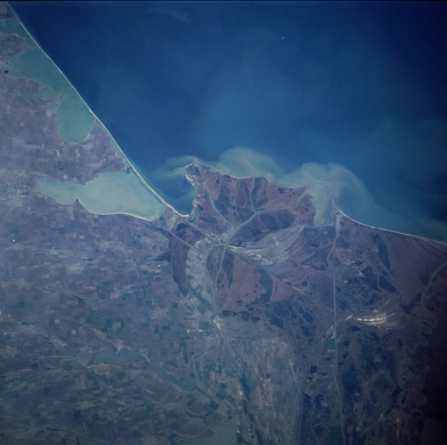 |
| NASA7-720-006 Danube River Delta, Romania/Ukraine Winter/Spring 1998 The northern half of the Danube River Delta, the largest continuous marshland in Europe, which includes one of the greatest stretches of reed beds in the world, can be seen in this east-looking view. The Danube is the second longest river in Europe meandering across the continent for 1750 miles (2800 Km). About 50 miles (80 Km) from the Black Sea (upper center and upper right of the image), the Danube begins to spread out into its delta, dividing into three major channels and multitudes of minor ones. The second largest delta in Europe, the Danube River Delta covers an area of nearly 1650 square miles (4300 square Km). The delta is a triangular swampy area of marshes, floating reed islands, and sandbanks, and is home of an almost unbelievable array of plants and wildlife. Best known for its birds, it also harbors numerous kinds of fish, herbs of wild boar, and an astonishing assortment of other creatures. Famed as one of the most prolific wildlife sanctuaries in Europe, the Danube River Delta attracts tourists and nature lovers from all around the world. Much of the field patterns visible on the left side of the image are in the country of the Ukraine. |
| Images: | All Available Images Low-Resolution 288k |
|
| Mission: | NASA7 |
|
| Roll - Frame: | 720 - 6 |
|
| Geographical Name: | ROMANIA |
|
| Features: | DANUBE DELTA,KILIYA,AGR. |
|
| Center Lat x Lon: | 45.5N x 29.5E |
|
| Film Exposure: | N | N=Normal exposure, U=Under exposed, O=Over exposed, F=out of Focus |
| Percentage of Cloud Cover-CLDP: | 0 |
|
| Camera:: | HB |
|
| Camera Tilt: | LO | LO=Low Oblique, HO=High Oblique, NV=Near Vertical |
| Camera Focal Length: | 100 |
|
| Nadir to Photo Center Direction: | The direction from the nadir to the center point, N=North, S=South, E=East, W=West |
|
| Stereo?: | Y | Y=Yes there is an adjacent picture of the same area, N=No there isn't |
| Orbit Number: | |
|
| Date: | 19980416 | YYYYMMDD |
| Time: | GMT HHMMSS |
|
| Nadir Lat: | N |
Latitude of suborbital point of spacecraft |
| Nadir Lon: | E |
Longitude of suborbital point of spacecraft |
| Sun Azimuth: | Clockwise angle in degrees from north to the sun measured at the nadir point |
|
| Space Craft Altitude: | nautical miles |
|
| Sun Elevation: | Angle in degrees between the horizon and the sun, measured at the nadir point |
|
| Land Views: | |
|
| Water Views: | RIVER, DELTA, SEDIMENT, LAGOON, CHANNEL |
|
| Atmosphere Views: | |
|
| Man Made Views: | AGRICULTURE |
|
| City Views: | |
|
Photo is not associated with any sequences | ||
| NASA Home Page |
JSC Home Page |
JSC Digital Image Collection |
Earth Science & Remote Sensing |
|
This service is provided by the International Space Station program and the JSC Earth Science & Remote Sensing Unit, ARES Division, Exploration Integration Science Directorate.

|