Geographic Region: RUSSIAN FEDERATION
Feature: VOLGA R., SARATOV, ICE
|
Geographic Region: RUSSIAN FEDERATION Feature: VOLGA R., SARATOV, ICE |
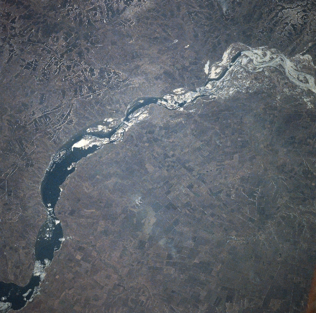 |
| NASA7-720-023 Volga River, Saratov/Engels, Russia Winter/Spring, 1998 The Volga River, winding its way through the Great Central Plateau of western Russia, can be seen in this northwest-looking view. Slightly above the center of the image, the cities of Engels (east bank) and Saratov (west bank) are discernible. The Volga River is the 18th longest river in the world and the longest river in Europe The river is the principal waterway of western Russia, being navigable from mid-April to late November (with locks by-passing numerous dams) almost throughout its entire course. This particular region of the Volga is located in the Great Central Plateau and encompasses fertile soils and numerous agricultural fields growing mostly grains. The region is subject to severe droughts. Both Saratov and Engels are river ports and industrial centers producing agricultural machinery, precision instruments, and machine tools. Oil refineries and chemical plants also make up the industrial base of both cities. This image was taken during the early Spring as ice flows (white features) are visible in the river. |
| Images: | All Available Images Low-Resolution 390k |
|
| Mission: | NASA7 |
|
| Roll - Frame: | 720 - 23 |
|
| Geographical Name: | RUSSIAN FEDERATION |
|
| Features: | VOLGA R., SARATOV, ICE |
|
| Center Lat x Lon: | 51.5N x 46.0E |
|
| Film Exposure: | N | N=Normal exposure, U=Under exposed, O=Over exposed, F=out of Focus |
| Percentage of Cloud Cover-CLDP: | 0 |
|
| Camera:: | HB |
|
| Camera Tilt: | LO | LO=Low Oblique, HO=High Oblique, NV=Near Vertical |
| Camera Focal Length: | 100 |
|
| Nadir to Photo Center Direction: | The direction from the nadir to the center point, N=North, S=South, E=East, W=West |
|
| Stereo?: | Y | Y=Yes there is an adjacent picture of the same area, N=No there isn't |
| Orbit Number: | |
|
| Date: | 19980417 | YYYYMMDD |
| Time: | GMT HHMMSS |
|
| Nadir Lat: | N |
Latitude of suborbital point of spacecraft |
| Nadir Lon: | E |
Longitude of suborbital point of spacecraft |
| Sun Azimuth: | Clockwise angle in degrees from north to the sun measured at the nadir point |
|
| Space Craft Altitude: | nautical miles |
|
| Sun Elevation: | Angle in degrees between the horizon and the sun, measured at the nadir point |
|
| Land Views: | PLATEAU |
|
| Water Views: | RIVER, RESERVOIR |
|
| Atmosphere Views: | |
|
| Man Made Views: | URBAN AREA, AGRICULTURE |
|
| City Views: | |
|
Photo is not associated with any sequences | ||
| NASA Home Page |
JSC Home Page |
JSC Digital Image Collection |
Earth Science & Remote Sensing |
|
This service is provided by the International Space Station program and the JSC Earth Science & Remote Sensing Unit, ARES Division, Exploration Integration Science Directorate.

|