Geographic Region: VENEZUELA
Feature: CUMANA, PORLAMAR,ISLANDS
|
Geographic Region: VENEZUELA Feature: CUMANA, PORLAMAR,ISLANDS |
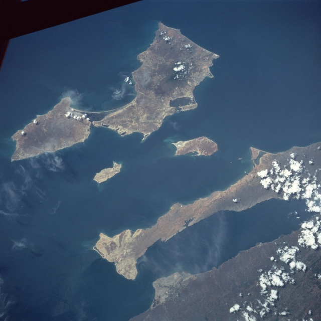 |
| NASA7-717-059 Araya Peninsula, Margarita Island, Venezuela Winter/Spring 1998 This northeast-looking view shows the large island of Margarita, the Araya Peninsula, and the Gulf of Cariaco. Margarita Island has an area of 444 sq. miles (1150 sq. km) and is the top of a submerged mountain range that parallels the Venezuelan coast. Its chief city is Porlamar (barely discernible), located on the southeast side of the island. In 1969, the island was developed as a free port offering extensive tourist facilities. Tourism is now one of the leading industries of the island. The two islands to the south of Margarita Island are Cubagua (smaller) and Coche. The Araya Peninsula is actually an extension of the Paria Peninsula, further east, comprising the Northern Mountain Range. The Gulf of Cariaco to the south of the Araya Peninsula is an arm of the Caribbean Sea. The city of Cumana (bottom center) is the oldest existing European settlement in South America. Cumana has often suffered from earthquakes. |
| Images: | All Available Images Low-Resolution 271k |
|
| Mission: | NASA7 |
|
| Roll - Frame: | 717 - 59 |
|
| Geographical Name: | VENEZUELA |
|
| Features: | CUMANA, PORLAMAR,ISLANDS |
|
| Center Lat x Lon: | 10.5N x 64W |
|
| Film Exposure: | N | N=Normal exposure, U=Under exposed, O=Over exposed, F=out of Focus |
| Percentage of Cloud Cover-CLDP: | 10 |
|
| Camera:: | HB |
|
| Camera Tilt: | LO | LO=Low Oblique, HO=High Oblique, NV=Near Vertical |
| Camera Focal Length: | 250 |
|
| Nadir to Photo Center Direction: | The direction from the nadir to the center point, N=North, S=South, E=East, W=West |
|
| Stereo?: | N | Y=Yes there is an adjacent picture of the same area, N=No there isn't |
| Orbit Number: | |
|
| Date: | 19980411 | YYYYMMDD |
| Time: | GMT HHMMSS |
|
| Nadir Lat: | N |
Latitude of suborbital point of spacecraft |
| Nadir Lon: | E |
Longitude of suborbital point of spacecraft |
| Sun Azimuth: | Clockwise angle in degrees from north to the sun measured at the nadir point |
|
| Space Craft Altitude: | nautical miles |
|
| Sun Elevation: | Angle in degrees between the horizon and the sun, measured at the nadir point |
|
| Land Views: | ISLAND, HILL, FAULT |
|
| Water Views: | GULF |
|
| Atmosphere Views: | |
|
| Man Made Views: | URBAN AREA |
|
| City Views: | |
|
Photo is not associated with any sequences | ||
| NASA Home Page |
JSC Home Page |
JSC Digital Image Collection |
Earth Science & Remote Sensing |
|
This service is provided by the International Space Station program and the JSC Earth Science & Remote Sensing Unit, ARES Division, Exploration Integration Science Directorate.

|