
Geographic Region: AUSTRALIA-NSW
Feature: MELBOURNE,PO. PHILLIP B.
|
Geographic Region: AUSTRALIA-NSW Feature: MELBOURNE,PO. PHILLIP B. |
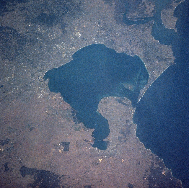 |
| NASA7-709-083 Port Phillip Bay, Victoria, Australia Winter/Spring 1998 Port Phillip Bay (large, dark feature center of the image) is the key to identifying several of the major landforms in this synoptic, east-looking view of the greater Melbourne region. Sand bars, shallow water, and islands are located at the southern edge of the bay near its mouth. The smaller bay along the western extent of Port Phillip Bay is Corio Bay. The city of Geelong in located along the western rim of Corio Bay. Bellarine Peninsula forms a sizeable landmass that separates the western half of Port Phillip Bay from the waters of Bass Strait (right side of image). The metropolitan area of Melbourne, Australia's second largest city (3.5 million people) and capital of Victoria can be identified along the north, northeast side of Port Phillip Bay (left middle edge). The Yarra River Valley (thin, dark linear feature) can be traced through downtown Melbourne, as the river weaves its way from the northeast to its discharge into the north side of Port Phillip Bay. Mornington Peninsula can also be identified as the land that separates the eastern side of the large bay from Western Port Bay (upper right corner). Darker areas throughout the image show the distribution and location of forest reserves and woodlands. |
| Images: | All Available Images Low-Resolution 390k |
|
| Mission: | NASA7 |
|
| Roll - Frame: | 709 - 83 |
|
| Geographical Name: | AUSTRALIA-NSW |
|
| Features: | MELBOURNE,PO. PHILLIP B. |
|
| Center Lat x Lon: | 38S x 145.0E |
|
| Film Exposure: | N | N=Normal exposure, U=Under exposed, O=Over exposed, F=out of Focus |
| Percentage of Cloud Cover-CLDP: | 0 |
|
| Camera:: | HB |
|
| Camera Tilt: | NV | LO=Low Oblique, HO=High Oblique, NV=Near Vertical |
| Camera Focal Length: | 250 |
|
| Nadir to Photo Center Direction: | The direction from the nadir to the center point, N=North, S=South, E=East, W=West |
|
| Stereo?: | Y | Y=Yes there is an adjacent picture of the same area, N=No there isn't |
| Orbit Number: | |
|
| Date: | 19980309 | YYYYMMDD |
| Time: | GMT HHMMSS |
|
| Nadir Lat: | N |
Latitude of suborbital point of spacecraft |
| Nadir Lon: | E |
Longitude of suborbital point of spacecraft |
| Sun Azimuth: | Clockwise angle in degrees from north to the sun measured at the nadir point |
|
| Space Craft Altitude: | nautical miles |
|
| Sun Elevation: | Angle in degrees between the horizon and the sun, measured at the nadir point |
|
| Land Views: | PENINSULA, FOREST |
|
| Water Views: | RIVER, BAY |
|
| Atmosphere Views: | |
|
| Man Made Views: | |
|
| City Views: | |
|
Photo is not associated with any sequences | ||
| NASA Home Page |
JSC Home Page |
JSC Digital Image Collection |
Earth Science & Remote Sensing |
|
This service is provided by the International Space Station program and the JSC Earth Science & Remote Sensing Unit, ARES Division, Exploration Integration Science Directorate.

|