
Geographic Region: MEXICO
Feature: ACAPULCO
|
Geographic Region: MEXICO Feature: ACAPULCO |
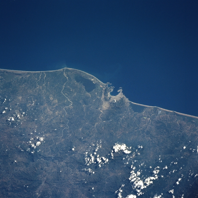 |
| NASA6-712-052 Sierra Madre del Sur, Acapulco, Mexico Fall/Winter 1997 The rugged mountains of the Sierra Madre del Sur (bottom portion of image) and the vacation resort city of Acapulco (near the center of the image) are discernible in this south-looking view. The Sierra Madre del Sur or as it is sometimes referred to, the Southern Highlands, are made up of ancient crystalline rock that has been dissected into deep V-shaped valleys creating a landscape of steep slopes and knife-edged ridges. Acapulco and its excellent harbor, is fairly isolated by the rugged ranges of the Sierra Madre del Sur to its north. The city is a shipping point for the agricultural products of the region and has suffered frequent earthquakes and hurricanes. A major hurricane during the late summer of 1997 brought above normal amounts of precipitation to the mountains of the Sierra Madre del Sur and the coastal regions surrounding the city of Acapulco. Flooded streams brought water, mud, and debris down the mountain slopes into the city, destroying many homes and other buildings. Many people were killed or injured and many more were made homeless. |
| Images: | All Available Images Low-Resolution 329k |
|
| Mission: | NASA6 |
|
| Roll - Frame: | 712 - 52 |
|
| Geographical Name: | MEXICO |
|
| Features: | ACAPULCO |
|
| Center Lat x Lon: | 17.0N x 100W |
|
| Film Exposure: | N | N=Normal exposure, U=Under exposed, O=Over exposed, F=out of Focus |
| Percentage of Cloud Cover-CLDP: | 5 |
|
| Camera:: | HB |
|
| Camera Tilt: | LO | LO=Low Oblique, HO=High Oblique, NV=Near Vertical |
| Camera Focal Length: | 100 |
|
| Nadir to Photo Center Direction: | The direction from the nadir to the center point, N=North, S=South, E=East, W=West |
|
| Stereo?: | N | Y=Yes there is an adjacent picture of the same area, N=No there isn't |
| Orbit Number: | |
|
| Date: | 19980105 | YYYYMMDD |
| Time: | GMT HHMMSS |
|
| Nadir Lat: | N |
Latitude of suborbital point of spacecraft |
| Nadir Lon: | E |
Longitude of suborbital point of spacecraft |
| Sun Azimuth: | Clockwise angle in degrees from north to the sun measured at the nadir point |
|
| Space Craft Altitude: | nautical miles |
|
| Sun Elevation: | Angle in degrees between the horizon and the sun, measured at the nadir point |
|
| Land Views: | MOUNTAIN, COAST, FOREST, FAULT |
|
| Water Views: | RIVER, LAGOON |
|
| Atmosphere Views: | |
|
| Man Made Views: | URBAN AREA |
|
| City Views: | ACAPULCO |
|
Photo is not associated with any sequences | ||
| NASA Home Page |
JSC Home Page |
JSC Digital Image Collection |
Earth Science & Remote Sensing |
|
This service is provided by the International Space Station program and the JSC Earth Science & Remote Sensing Unit, ARES Division, Exploration Integration Science Directorate.

|