
Geographic Region: VENEZUELA
Feature: TABLAZO BAY
|
Geographic Region: VENEZUELA Feature: TABLAZO BAY |
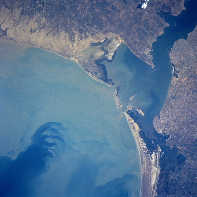 |
| NASA6-712-031 Tablazo Bay, Gulf of Venezuela, Venezuela Fall 1997 The Gulf of Venezuela with a heavy load of sediment occupies most of the left portion of this near-vertical-looking view. An inlet of the Caribbean Sea, the Gulf is a major shipping lane for Venezuelan oil. The oil is shipped from ports in Maracaibo (upper right) and the new city of Tablazo across the Bay of Tablazo from Maracaibo. The bay is constantly dredged to allow the passage of large oil tankers to and from the ports of Maracaibo and Tablazo and other ports in the northeastern part of Lake Maracaibo (not visible on image). This whole region is considered the oil capital of South America. |
| Images: | All Available Images Low-Resolution 313k |
|
| Mission: | NASA6 |
|
| Roll - Frame: | 712 - 31 |
|
| Geographical Name: | VENEZUELA |
|
| Features: | TABLAZO BAY |
|
| Center Lat x Lon: | 11.0N x 71.5W |
|
| Film Exposure: | N | N=Normal exposure, U=Under exposed, O=Over exposed, F=out of Focus |
| Percentage of Cloud Cover-CLDP: | 0 |
|
| Camera:: | HB |
|
| Camera Tilt: | LO | LO=Low Oblique, HO=High Oblique, NV=Near Vertical |
| Camera Focal Length: | 100 |
|
| Nadir to Photo Center Direction: | The direction from the nadir to the center point, N=North, S=South, E=East, W=West |
|
| Stereo?: | Y | Y=Yes there is an adjacent picture of the same area, N=No there isn't |
| Orbit Number: | |
|
| Date: | 19980105 | YYYYMMDD |
| Time: | GMT HHMMSS |
|
| Nadir Lat: | N |
Latitude of suborbital point of spacecraft |
| Nadir Lon: | E |
Longitude of suborbital point of spacecraft |
| Sun Azimuth: | Clockwise angle in degrees from north to the sun measured at the nadir point |
|
| Space Craft Altitude: | nautical miles |
|
| Sun Elevation: | Angle in degrees between the horizon and the sun, measured at the nadir point |
|
| Land Views: | COAST |
|
| Water Views: | GULF, BAY, SEDIMENT, RIVER |
|
| Atmosphere Views: | |
|
| Man Made Views: | URBAN AREA |
|
| City Views: | |
|
Photo is not associated with any sequences | ||
| NASA Home Page |
JSC Home Page |
JSC Digital Image Collection |
Earth Science & Remote Sensing |
|
This service is provided by the International Space Station program and the JSC Earth Science & Remote Sensing Unit, ARES Division, Exploration Integration Science Directorate.

|