
Geographic Region: SWITZERLAND
Feature: ALPS, CONSTANCE LAKE
|
Geographic Region: SWITZERLAND Feature: ALPS, CONSTANCE LAKE |
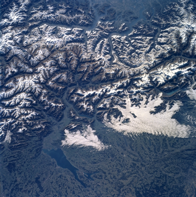 |
| NASA6-710-012 Lake Constance, Alps, Switzerland Fall/Winter 1997 The majestic snow-covered Alps can be seen in the southeastern-looking view. The Alps are the highest mountain range in Europe. The Alps began to form nearly 40 million years ago and continue to grow today as the Africa plate continues to move northward into the European plate. The core of the Alps is composed of hard crystalline rocks, mainly granite, gneiss, and mica schist. Spreading out from this core region is a wide zone of softer sedimentary rocks, mainly hard limestone and weaker sandstones and shale. The Alps form a barrier between the warm air of the Mediterranean to the south and the colder temperatures of northern Europe. The part of the Alps shown in this image is the source of the Rhine River. In the bottom left portion of the image, Lake Constance is discernible. The lake, which is 42 miles (68 km) long and covers an area of 208 square miles (539 square km), is fed by and drained by the Rhine River. The lake has a maximum depth of 827 feet (252 meters). Fruit is grown on the lake's fertile shores, and wine making, fishing, and tourism are major industries. |
| Images: | All Available Images Low-Resolution 415k |
|
| Mission: | NASA6 |
|
| Roll - Frame: | 710 - 12 |
|
| Geographical Name: | SWITZERLAND |
|
| Features: | ALPS, CONSTANCE LAKE |
|
| Center Lat x Lon: | 47.0N x 9.5E |
|
| Film Exposure: | N | N=Normal exposure, U=Under exposed, O=Over exposed, F=out of Focus |
| Percentage of Cloud Cover-CLDP: | 5 |
|
| Camera:: | HB |
|
| Camera Tilt: | LO | LO=Low Oblique, HO=High Oblique, NV=Near Vertical |
| Camera Focal Length: | 100 |
|
| Nadir to Photo Center Direction: | The direction from the nadir to the center point, N=North, S=South, E=East, W=West |
|
| Stereo?: | Y | Y=Yes there is an adjacent picture of the same area, N=No there isn't |
| Orbit Number: | |
|
| Date: | 19971029 | YYYYMMDD |
| Time: | GMT HHMMSS |
|
| Nadir Lat: | N |
Latitude of suborbital point of spacecraft |
| Nadir Lon: | E |
Longitude of suborbital point of spacecraft |
| Sun Azimuth: | Clockwise angle in degrees from north to the sun measured at the nadir point |
|
| Space Craft Altitude: | nautical miles |
|
| Sun Elevation: | Angle in degrees between the horizon and the sun, measured at the nadir point |
|
| Land Views: | MOUNTAIN, FAULT, GLACIER |
|
| Water Views: | LAKE |
|
| Atmosphere Views: | |
|
| Man Made Views: | |
|
| City Views: | |
|
Photo is not associated with any sequences | ||
| NASA Home Page |
JSC Home Page |
JSC Digital Image Collection |
Earth Science & Remote Sensing |
|
This service is provided by the International Space Station program and the JSC Earth Science & Remote Sensing Unit, ARES Division, Exploration Integration Science Directorate.

|