
Geographic Region: ITALY
Feature: GULF OF TARANTO
|
Geographic Region: ITALY Feature: GULF OF TARANTO |
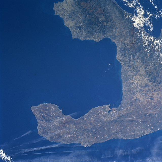 |
| NASA6-709-009 Puglia, Italy Fall/Winter 1997 The Salentino Peninsula (bottom of image), also known as "the heel of Italy," is the elongated promontory that juts southeasterly from the larger Italian Peninsula. This peninsula is bordered by the Adriatic Sea to the northeast (bottom of image) and the Gulf of Taranto to the southwest (center of image). The peninsula consists of gently rolling hills and coastal plains, thereby promoting an agrarian economy. The numerous, light colored, speckled-looking spots seen throughout the peninsula shows the location of small agricultural towns and villages. There is an industrial triangle that extends from Taranto, noted for its large steel-making facility (northern coast of Gulf of Taranto) to Brindisi, known for its chemical plants (bottom center along Adriatic Sea), and finally to Bari, the most notable city with a diversified industrial base (along Adriatic coast-bottom right). The northeastern portion of the Calabrian Mountains can be seen along the top edge of the picture. A few wispy-looking clouds can be seen at the bottom of the image but the long, linear white features are contrails from jet aircraft. |
| Images: | All Available Images Low-Resolution 305k |
|
| Mission: | NASA6 |
|
| Roll - Frame: | 709 - 9 |
|
| Geographical Name: | ITALY |
|
| Features: | GULF OF TARANTO |
|
| Center Lat x Lon: | 40.0N x 17.5E |
|
| Film Exposure: | N | N=Normal exposure, U=Under exposed, O=Over exposed, F=out of Focus |
| Percentage of Cloud Cover-CLDP: | 5 |
|
| Camera:: | HB |
|
| Camera Tilt: | LO | LO=Low Oblique, HO=High Oblique, NV=Near Vertical |
| Camera Focal Length: | 100 |
|
| Nadir to Photo Center Direction: | The direction from the nadir to the center point, N=North, S=South, E=East, W=West |
|
| Stereo?: | N | Y=Yes there is an adjacent picture of the same area, N=No there isn't |
| Orbit Number: | |
|
| Date: | 19971027 | YYYYMMDD |
| Time: | GMT HHMMSS |
|
| Nadir Lat: | N |
Latitude of suborbital point of spacecraft |
| Nadir Lon: | E |
Longitude of suborbital point of spacecraft |
| Sun Azimuth: | Clockwise angle in degrees from north to the sun measured at the nadir point |
|
| Space Craft Altitude: | nautical miles |
|
| Sun Elevation: | Angle in degrees between the horizon and the sun, measured at the nadir point |
|
| Land Views: | PENINSULA, MOUNTAIN |
|
| Water Views: | GULF, SEA |
|
| Atmosphere Views: | |
|
| Man Made Views: | |
|
| City Views: | |
|
Photo is not associated with any sequences | ||
| NASA Home Page |
JSC Home Page |
JSC Digital Image Collection |
Earth Science & Remote Sensing |
|
This service is provided by the International Space Station program and the JSC Earth Science & Remote Sensing Unit, ARES Division, Exploration Integration Science Directorate.

|