 Photo #: NASA6-703-44 Date: Oct. 1997
Geographic Region: ITALY
Feature: PO RIVER VALLEY, SMOG

 Photo #: NASA6-703-44 Date: Oct. 1997 Photo #: NASA6-703-44 Date: Oct. 1997Geographic Region: ITALY Feature: PO RIVER VALLEY, SMOG |
 |
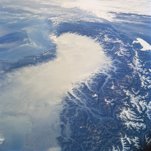
| NASA6-703-044 Po River Valley Smog, Italy Fall/Winter 1997 The snow capped higher elevations of the Italian, Swiss, and French Alps mountains provide a natural barrier to the outward migration of smog shown here filling the Po River Valley of northern Italy. This southwest-looking view shows a dense sea of air pollution (extensive, lighter colored area-center of image) that is trapped from time to time by air stagnation in the heavily industrialized Po River Valley. The picture shows that air pollution even infiltrates the numerous mountain valleys that surround this river basin. The smog appears to be less dense towards the eastern side of the basin where the terrain is visible though the hazy-looking atmosphere. A small section of the Rhone River Valley can be traced through the Swiss Alps near the right edge (middle) and the small patch of whiteness along the right edge (middle) is a low deck of clouds over Lake Geneva. |
| Images: | All Available Images Low-Resolution 347k |
|
| Mission: | NASA6 |
|
| Roll - Frame: | 703 - 44 |
|
| Geographical Name: | ITALY |
|
| Features: | PO RIVER VALLEY, SMOG |
|
| Center Lat x Lon: | 45.5N x 10.0E |
|
| Film Exposure: | N | N=Normal exposure, U=Under exposed, O=Over exposed, F=out of Focus |
| Percentage of Cloud Cover-CLDP: | 20 |
|
| Camera:: | HB |
|
| Camera Tilt: | LO | LO=Low Oblique, HO=High Oblique, NV=Near Vertical |
| Camera Focal Length: | 100 |
|
| Nadir to Photo Center Direction: | The direction from the nadir to the center point, N=North, S=South, E=East, W=West |
|
| Stereo?: | N | Y=Yes there is an adjacent picture of the same area, N=No there isn't |
| Orbit Number: | |
|
| Date: | 19971019 | YYYYMMDD |
| Time: | GMT HHMMSS |
|
| Nadir Lat: | N |
Latitude of suborbital point of spacecraft |
| Nadir Lon: | E |
Longitude of suborbital point of spacecraft |
| Sun Azimuth: | Clockwise angle in degrees from north to the sun measured at the nadir point |
|
| Space Craft Altitude: | nautical miles |
|
| Sun Elevation: | Angle in degrees between the horizon and the sun, measured at the nadir point |
|
| Land Views: | MOUNTAIN, VALLEY, BASIN |
|
| Water Views: | LAKE, RIVER, SEA |
|
| Atmosphere Views: | SMOG, DUST |
|
| Man Made Views: | POLLUTION |
|
| City Views: | |
|
Photo is not associated with any sequences | ||
| NASA Home Page |
JSC Home Page |
JSC Digital Image Collection |
Earth Science & Remote Sensing |
|
|