Geographic Region: CHINA
Feature: KUNLUN MOUNTAINS
|
Geographic Region: CHINA Feature: KUNLUN MOUNTAINS |
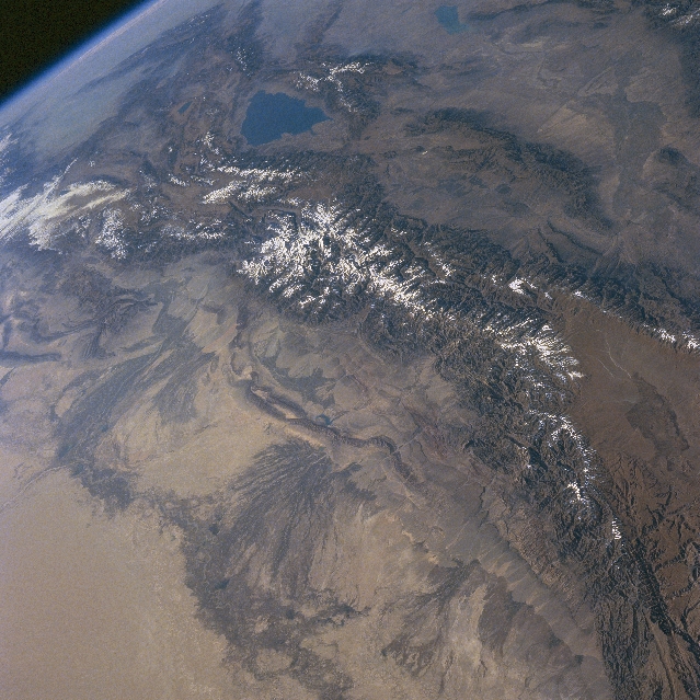 |
| NASA6-701-038 Tien Shan (Mountains), China Fall/Winter 1997 The snow covered Tien Shan, that lie along a generally east/west axis in central Asia, separate the Dzungarian Basin (north) and the Tarim Basin of western China (south). The mountains are the result of geologic folding and uplift. The crystalline and sedimentary rocks in this mountainous region have been subjected to intensive erosion and faulting. Although the climate of the region is arid to semiarid (steppe), melting snow from the Tien Shan provides sufficient moisture to promote agriculture on the extensive alluvial fans (dark striated areas) that stretch along the southern margin of the mountains. Beyond (south) these alluvium oasis lays the Takla Makan Desert (lower left). The blue triangular-looking feature (upper center) is Lake Issyk-Kul, which is located entirely within the borders of Kyrgyzstan. The mountain range immediately north of the lake is the border between Kyrgyzstan and Kazakhstan. Western China is south of the Tian Shan. |
| Images: | All Available Images Low-Resolution 375k |
|
| Mission: | NASA6 |
|
| Roll - Frame: | 701 - 38 |
|
| Geographical Name: | CHINA |
|
| Features: | KUNLUN MOUNTAINS |
|
| Center Lat x Lon: | 38.0N x 93.0E |
|
| Film Exposure: | N | N=Normal exposure, U=Under exposed, O=Over exposed, F=out of Focus |
| Percentage of Cloud Cover-CLDP: | 5 |
|
| Camera:: | HB |
|
| Camera Tilt: | HO | LO=Low Oblique, HO=High Oblique, NV=Near Vertical |
| Camera Focal Length: | 100 |
|
| Nadir to Photo Center Direction: | The direction from the nadir to the center point, N=North, S=South, E=East, W=West |
|
| Stereo?: | N | Y=Yes there is an adjacent picture of the same area, N=No there isn't |
| Orbit Number: | |
|
| Date: | 19971018 | YYYYMMDD |
| Time: | GMT HHMMSS |
|
| Nadir Lat: | N |
Latitude of suborbital point of spacecraft |
| Nadir Lon: | E |
Longitude of suborbital point of spacecraft |
| Sun Azimuth: | Clockwise angle in degrees from north to the sun measured at the nadir point |
|
| Space Craft Altitude: | nautical miles |
|
| Sun Elevation: | Angle in degrees between the horizon and the sun, measured at the nadir point |
|
| Land Views: | MOUNTAIN, BASIN, ALLUVIAL FAN, FAULT, DESERT |
|
| Water Views: | LAKE |
|
| Atmosphere Views: | |
|
| Man Made Views: | AGRICULTURE |
|
| City Views: | |
|
Photo is not associated with any sequences | ||
| NASA Home Page |
JSC Home Page |
JSC Digital Image Collection |
Earth Science & Remote Sensing |
|
This service is provided by the International Space Station program and the JSC Earth Science & Remote Sensing Unit, ARES Division, Exploration Integration Science Directorate.

|