
Geographic Region: SOMALIA
Feature: HORN OF AFRICA, OGO MOUNTAINS, GULF OF ADEN
|
Geographic Region: SOMALIA Feature: HORN OF AFRICA, OGO MOUNTAINS, GULF OF ADEN |
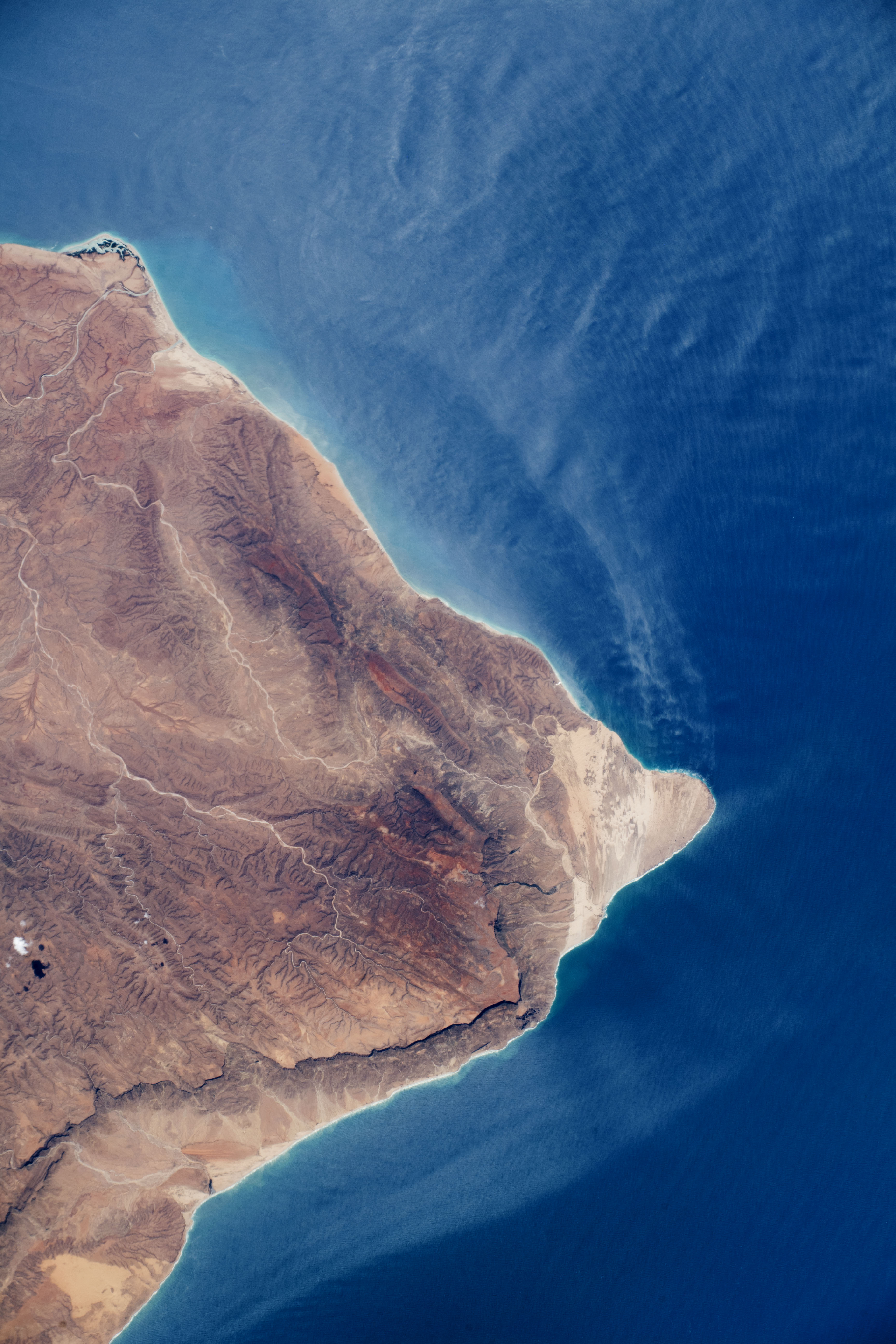
| The Horn of Africa, Somalia An astronaut aboard the International Space Station (ISS) shot this photograph of the Horn of Africa, the easternmost portion of the continent. Raas Caseyr, historically known as Cape Guardafui, lies at the junction between the Gulf of Aden and the Indian Ocean. The coastline is rugged, with mountains, dry river beds, a small delta, and steep cliffs that cast shadows on the landscape. This arid region is an extension of the Saharan and Arabian deserts. Strong southerly winds are common from May to October during the southwest monsoon season (when this image was taken). The winds transport sand across the cape and create a series of dunes (visible in the high-resolution download of this image). Sand is then transported into the Gulf as streamers that contrast with the darker sea surface. Dust storms are common in the Gulf of Aden-Red Sea region and have been photographed by astronauts on other occasions, including a wind storm near the southern Red Sea and a plume from Egypt. In May 2018, approximately one month before this image was taken, Somalia was hit by a tropical cyclone - a rare event for the region because dry desert air typically weakens storms. |
| Images: | All Available Images Low-Resolution 462k |
|
| Mission: | ISS056 |
|
| Roll - Frame: | E - 5470 |
|
| Geographical Name: | SOMALIA |
|
| Features: | HORN OF AFRICA, OGO MOUNTAINS, GULF OF ADEN |
|
| Center Lat x Lon: | 11.8N x 51.1E |
|
| Film Exposure: | N=Normal exposure, U=Under exposed, O=Over exposed, F=out of Focus |
|
| Percentage of Cloud Cover-CLDP: | 10 |
|
| Camera:: | N8 |
|
| Camera Tilt: | 28 | LO=Low Oblique, HO=High Oblique, NV=Near Vertical |
| Camera Focal Length: | 170 |
|
| Nadir to Photo Center Direction: | N | The direction from the nadir to the center point, N=North, S=South, E=East, W=West |
| Stereo?: | Y=Yes there is an adjacent picture of the same area, N=No there isn't |
|
| Orbit Number: | |
|
| Date: | 20180604 | YYYYMMDD |
| Time: | 094510 | GMT HHMMSS |
| Nadir Lat: | 9.9N |
Latitude of suborbital point of spacecraft |
| Nadir Lon: | 51.3E |
Longitude of suborbital point of spacecraft |
| Sun Azimuth: | 308 | Clockwise angle in degrees from north to the sun measured at the nadir point |
| Space Craft Altitude: | 219 | nautical miles |
| Sun Elevation: | 69 | Angle in degrees between the horizon and the sun, measured at the nadir point |
| Land Views: | |
|
| Water Views: | |
|
| Atmosphere Views: | |
|
| Man Made Views: | |
|
| City Views: | |
|
Photo is not associated with any sequences | ||
| NASA Home Page |
JSC Home Page |
JSC Digital Image Collection |
Earth Science & Remote Sensing |
|
This service is provided by the International Space Station program and the JSC Earth Science & Remote Sensing Unit, ARES Division, Exploration Integration Science Directorate.

|