
Geographic Region: AUSTRALIA-SA
Feature: AGR., DRY LAKE, TALDRA, ROAD
|
Geographic Region: AUSTRALIA-SA Feature: AGR., DRY LAKE, TALDRA, ROAD |
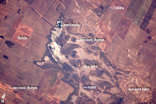 |
| South Australia wet and dry--Riverland and the River Murray An astronaut aboard the International Space Station captured these detailed photographs of agricultural patterns in the lower River Murray region of South Australia, a region known as the Riverland. Renmark (upper image, at image center) is one of its major towns in a line of many towns in Riverland along more than 100 km (60 miles) of the Murray. The upper image shows the winding course of the Murray in a wide floodplain with numerous small farm plots clustered along its banks. This heavily irrigated country produces more than half of South Australia's famed wine production, and is a mix of grapevines, almond groves, stone fruit orchards (like peaches and apricots), and citrus orchards. This intensely farmed landscape within reach of river irrigation contrasts with the arid landscape in the lower image, only 20 km south of Renmark. It shows a large dry lake (at image center to lower right) crossed by a winding road, with rounded, ancient dunes south of the settlement of Taldra. The dry lake has been the site for growth trials of a salt-tolerant giant cane crop, as reported by local agriculture officials. Surrounding the lake is sparser vegetation which allows the underlying tan-colored linear dunes to remain visible from space. The surrounding fields show faint parallel lines that indicate a plowing pattern. These fields are part of a mixed farming agriculture in which crops (mainly wheat and barley) are grown for two years, after which the fields provide pasture for grazing livestock. Other lakes in the Murray basin (also known as the Murray-Darling basin) are used for agriculture. These lakes and their field patterns make striking patterns that have attracted the attention of astronauts in the past [link to: https://eol.jsc.nasa.gov/Collections/EarthObservatory/articles/MenindeeLakesNewSouthWalesAustralia.htm ; https://eol.jsc.nasa.gov/Collections/EarthObservatory/articles/Lake_Tandou,New_South_Wales,Australia.htm ]. |
| Images: | All Available Images Low-Resolution 100k |
|
| Mission: | ISS050 |
|
| Roll - Frame: | E - 36713 |
|
| Geographical Name: | AUSTRALIA-SA |
|
| Features: | AGR., DRY LAKE, TALDRA, ROAD |
|
| Center Lat x Lon: | 34.4S x 140.8E |
|
| Film Exposure: | N=Normal exposure, U=Under exposed, O=Over exposed, F=out of Focus |
|
| Percentage of Cloud Cover-CLDP: | 0 |
|
| Camera:: | N6 |
|
| Camera Tilt: | 17 | LO=Low Oblique, HO=High Oblique, NV=Near Vertical |
| Camera Focal Length: | 1150 |
|
| Nadir to Photo Center Direction: | N | The direction from the nadir to the center point, N=North, S=South, E=East, W=West |
| Stereo?: | Y=Yes there is an adjacent picture of the same area, N=No there isn't |
|
| Orbit Number: | |
|
| Date: | 20170127 | YYYYMMDD |
| Time: | 213419 | GMT HHMMSS |
| Nadir Lat: | 35.5S |
Latitude of suborbital point of spacecraft |
| Nadir Lon: | 141.0E |
Longitude of suborbital point of spacecraft |
| Sun Azimuth: | 99 | Clockwise angle in degrees from north to the sun measured at the nadir point |
| Space Craft Altitude: | 221 | nautical miles |
| Sun Elevation: | 19 | Angle in degrees between the horizon and the sun, measured at the nadir point |
| Land Views: | BASIN |
|
| Water Views: | LAKE, RIVER |
|
| Atmosphere Views: | |
|
| Man Made Views: | AGRICULTURE, BRIDGE |
|
| City Views: | |
|
Photo is not associated with any sequences | ||
| NASA Home Page |
JSC Home Page |
JSC Digital Image Collection |
Earth Science & Remote Sensing |
|
This service is provided by the International Space Station program and the JSC Earth Science & Remote Sensing Unit, ARES Division, Exploration Integration Science Directorate.

|