
Geographic Region: USA-NEW YORK
Feature: PHILADELPHIA, NEW YORK, HARTFORD AT NIGHT
|
Geographic Region: USA-NEW YORK Feature: PHILADELPHIA, NEW YORK, HARTFORD AT NIGHT |
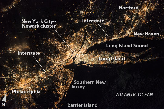 |
| New York City region at night An astronaut aboard the International Space Station (ISS) centered this night photograph on the most brilliant group of lights in the northeast US: New York city and Newark, NJ (at image center) lie at the center of the string of city lights stretching from a distance of 325 km (200 miles) from Philadelphia, PA (at image lower left) to Hartford, CT (top right). The characteristic shape of Long Island, during night and daylight passes may be the most recognizable feature to an astronaut. Lesser night-light intensity parallels lower population densities--well illustrated on Long Island--where the progressive decline of population density away from cores of the largest cities. This is a phenomenon well-known to urban geographers. Yet lower population densities appear in the southern counties of New Jersey in a dispersed settlement pattern that stretches 60 miles to Barnegat Bay (at image lower left). Here the barrier island is defined by narrow shoreline developments (at image lower left margin). Rural areas (at image top left) with the lowest populations have almost as few lights as the Atlantic Ocean (at image lower right). The network thin lines of highways and main roads--difficult to see in daylight images--radiate outward from the major cities (Philadelphia is the best example in this view). One of the brightest lines is Interstate 95 that crosses the entire image, from a point west of Philadelphia, through New York--where it is drowned out New York city lights--and along the coast of Long Island Sound to New Haven and further east. Astronauts choose a lens for the size of the area they want to capture in an image. This image was taken with a short (45 mm) lens. It shows the difference in area compared with that captured by a long lens (800 mm)--as used for example, for images of Manhattan and Brooklyn. |
| Images: | All Available Images Low-Resolution 106k |
|
| Mission: | ISS050 |
|
| Roll - Frame: | E - 29655 |
|
| Geographical Name: | USA-NEW YORK |
|
| Features: | PHILADELPHIA, NEW YORK, HARTFORD AT NIGHT |
|
| Center Lat x Lon: | 40.5N x 73.5W |
|
| Film Exposure: | N=Normal exposure, U=Under exposed, O=Over exposed, F=out of Focus |
|
| Percentage of Cloud Cover-CLDP: | 10 |
|
| Camera:: | N6 |
|
| Camera Tilt: | 20 | LO=Low Oblique, HO=High Oblique, NV=Near Vertical |
| Camera Focal Length: | 45 |
|
| Nadir to Photo Center Direction: | S | The direction from the nadir to the center point, N=North, S=South, E=East, W=West |
| Stereo?: | Y=Yes there is an adjacent picture of the same area, N=No there isn't |
|
| Orbit Number: | |
|
| Date: | 20170110 | YYYYMMDD |
| Time: | 073143 | GMT HHMMSS |
| Nadir Lat: | 41.7N |
Latitude of suborbital point of spacecraft |
| Nadir Lon: | 73.1W |
Longitude of suborbital point of spacecraft |
| Sun Azimuth: | 70 | Clockwise angle in degrees from north to the sun measured at the nadir point |
| Space Craft Altitude: | 213 | nautical miles |
| Sun Elevation: | -53 | Angle in degrees between the horizon and the sun, measured at the nadir point |
| Land Views: | |
|
| Water Views: | |
|
| Atmosphere Views: | |
|
| Man Made Views: | |
|
| City Views: | |
|
Photo is not associated with any sequences | ||
| NASA Home Page |
JSC Home Page |
JSC Digital Image Collection |
Earth Science & Remote Sensing |
|
This service is provided by the International Space Station program and the JSC Earth Science & Remote Sensing Unit, ARES Division, Exploration Integration Science Directorate.

|