
Geographic Region: SUDAN
Feature: MEIDOB VOLCANIC FIELD, SCORIA CONES, MAAR CRATERS, LAVA FLOWS, WASHES
|
Geographic Region: SUDAN Feature: MEIDOB VOLCANIC FIELD, SCORIA CONES, MAAR CRATERS, LAVA FLOWS, WASHES |
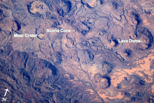 |
| Meidob Volcanic Field This photograph of the central Meidob Volcanic Field was taken by an astronaut onboard the International Space Station. The entire field covers an area of approximately 5,000 square kilometers (approximately 1,930 square miles) of western Sudan. There are numerous vents (nearly 700) that are believed by geologists to be less than 6 million years old. The most recent eruptive activity in the field has been dated to within 500 years of 2950 BCE, or roughly spanning the time of the unification of the Upper and Lower kingdoms of ancient Egypt. While the majority of the Meidob field is comprised of volcanic rocks with significant iron and magnesium (basalt), the central region depicted here is dominated by volcanic rocks that have relatively higher amounts of sodium and potassium than basalt (known as trachyte and phonolite to geologists). This part of the volcanic field is also distinctive for the landforms that are common here, such as explosively-formed maar craters, lava domes built by viscous lava flows, and scoria or cinder cones formed around a single volcanic vent. |
| Images: | All Available Images Low-Resolution 118k |
|
| Mission: | ISS050 |
|
| Roll - Frame: | E - 29426 |
|
| Geographical Name: | SUDAN |
|
| Features: | MEIDOB VOLCANIC FIELD, SCORIA CONES, MAAR CRATERS, LAVA FLOWS, WASHES |
|
| Center Lat x Lon: | 15.3N x 26.6E |
|
| Film Exposure: | N=Normal exposure, U=Under exposed, O=Over exposed, F=out of Focus |
|
| Percentage of Cloud Cover-CLDP: | 10 |
|
| Camera:: | N6 |
|
| Camera Tilt: | 29 | LO=Low Oblique, HO=High Oblique, NV=Near Vertical |
| Camera Focal Length: | 1150 |
|
| Nadir to Photo Center Direction: | S | The direction from the nadir to the center point, N=North, S=South, E=East, W=West |
| Stereo?: | Y=Yes there is an adjacent picture of the same area, N=No there isn't |
|
| Orbit Number: | |
|
| Date: | 20170101 | YYYYMMDD |
| Time: | 123056 | GMT HHMMSS |
| Nadir Lat: | 17.2N |
Latitude of suborbital point of spacecraft |
| Nadir Lon: | 26.0E |
Longitude of suborbital point of spacecraft |
| Sun Azimuth: | 220 | Clockwise angle in degrees from north to the sun measured at the nadir point |
| Space Craft Altitude: | 219 | nautical miles |
| Sun Elevation: | 39 | Angle in degrees between the horizon and the sun, measured at the nadir point |
| Land Views: | |
|
| Water Views: | |
|
| Atmosphere Views: | |
|
| Man Made Views: | |
|
| City Views: | |
|
Photo is not associated with any sequences | ||
| NASA Home Page |
JSC Home Page |
JSC Digital Image Collection |
Earth Science & Remote Sensing |
|
This service is provided by the International Space Station program and the JSC Earth Science & Remote Sensing Unit, ARES Division, Exploration Integration Science Directorate.

|