
Geographic Region: ATMOSPHERIC LIMB
Feature: SUNSET, SOUTH ATLANTIC OCEAN
|
Geographic Region: ATMOSPHERIC LIMB Feature: SUNSET, SOUTH ATLANTIC OCEAN |
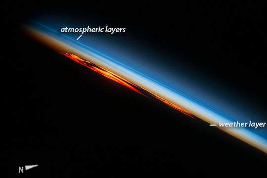 |
| Fiery South Atlantic Sunset An astronaut aboard the International Space Station (ISS) photographed this sunset that looks like a vast sheet of flame. With the Earth's surface already in darkness, setting sun and cloud masses, and the sideways viewing angle make a powerful image, of the kind that astronauts like to take to commemorate their flights. Thin layers of lighter and darker blues reveal the many layers of the atmosphere above the lowest layer - the brown layer with its clouds and dust and smoke (known to scientists as the troposphere, the layer of weather as we experience it). It is the smoke and particles of dust in the atmosphere that give the strong red color to sunsets. Unlike most of us, astronauts see the atmosphere side-on, every 90 minutes, as in this view, with sixteen sunrises and sixteen sunsets every day. Astronauts often comment on how thin and fragile the Earth's atmosphere seems. |
| Images: | All Available Images Low-Resolution 40k |
|
| Mission: | ISS049 |
|
| Roll - Frame: | E - 49442 |
|
| Geographical Name: | ATMOSPHERIC LIMB |
|
| Features: | SUNSET, SOUTH ATLANTIC OCEAN |
|
| Center Lat x Lon: | N x E |
|
| Film Exposure: | N=Normal exposure, U=Under exposed, O=Over exposed, F=out of Focus |
|
| Percentage of Cloud Cover-CLDP: | 10 |
|
| Camera:: | N6 |
|
| Camera Tilt: | HO | LO=Low Oblique, HO=High Oblique, NV=Near Vertical |
| Camera Focal Length: | 240 |
|
| Nadir to Photo Center Direction: | The direction from the nadir to the center point, N=North, S=South, E=East, W=West |
|
| Stereo?: | Y=Yes there is an adjacent picture of the same area, N=No there isn't |
|
| Orbit Number: | |
|
| Date: | 20161027 | YYYYMMDD |
| Time: | 222954 | GMT HHMMSS |
| Nadir Lat: | 49.1S |
Latitude of suborbital point of spacecraft |
| Nadir Lon: | 13.1W |
Longitude of suborbital point of spacecraft |
| Sun Azimuth: | 213 | Clockwise angle in degrees from north to the sun measured at the nadir point |
| Space Craft Altitude: | 222 | nautical miles |
| Sun Elevation: | -22 | Angle in degrees between the horizon and the sun, measured at the nadir point |
| Land Views: | |
|
| Water Views: | |
|
| Atmosphere Views: | DUST, SMOKE |
|
| Man Made Views: | |
|
| City Views: | |
|
Photo is not associated with any sequences | ||
| NASA Home Page |
JSC Home Page |
JSC Digital Image Collection |
Earth Science & Remote Sensing |
|
This service is provided by the International Space Station program and the JSC Earth Science & Remote Sensing Unit, ARES Division, Exploration Integration Science Directorate.

|