
Geographic Region: TURKMENISTAN
Feature: PAN_CASPIAN, KARABOGAZ G., ELBURZ MTS.
|
Geographic Region: TURKMENISTAN Feature: PAN_CASPIAN, KARABOGAZ G., ELBURZ MTS. |
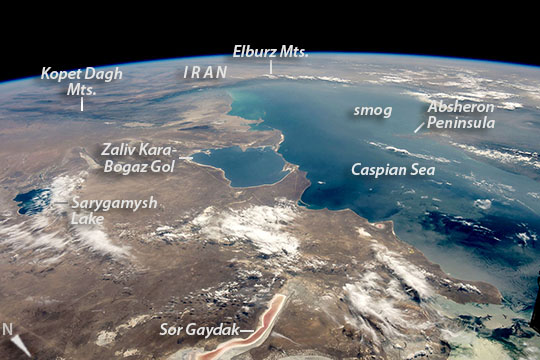 |
| Caspian Sea Looking south to the horizon, an astronaut aboard the International Space Station (ISS) took this photograph of most of the Caspian Sea and neighboring countries in inner Asia. Shorelines of water bodies are key features for astronauts trying to orient themselves over Earth. The south shore of the sea appears as a nearly straight line against the dark ranges of the Elburz Mountains of northern Iran. At a right-angled corner - a telltale feature of the Caspian Sea for astronauts looking down at Earth - the coastline veers due north, where it meets the 160 kilometer-wide (100 mile) bay in Turkmenistan known as Zaliv Kara-Bogaz Gol. The narrow spit that divides this gulf from the Caspian Sea is another well-known feature. Saltwater Lake Sarygamish lies on the Turkmenistan-Uzbekistan border, and the narrow Sor Gaydak channel in Kazakhstan shows its characteristic pink tone. The west side (right in this south-facing image) of the Caspian Sea lies under a thin smog layer, which partly obscures the finger of the Absheron Peninsula, the center of Azerbaijan's oil producing region. (Those facilities have previously been photographed in detail.) |
| Images: | All Available Images Low-Resolution 87k |
|
| Mission: | ISS048 |
|
| Roll - Frame: | E - 70125 |
|
| Geographical Name: | TURKMENISTAN |
|
| Features: | PAN_CASPIAN, KARABOGAZ G., ELBURZ MTS. |
|
| Center Lat x Lon: | 42.0N x 53.5E |
|
| Film Exposure: | N=Normal exposure, U=Under exposed, O=Over exposed, F=out of Focus |
|
| Percentage of Cloud Cover-CLDP: | 10 |
|
| Camera:: | N6 |
|
| Camera Tilt: | HO | LO=Low Oblique, HO=High Oblique, NV=Near Vertical |
| Camera Focal Length: | 36 |
|
| Nadir to Photo Center Direction: | S | The direction from the nadir to the center point, N=North, S=South, E=East, W=West |
| Stereo?: | Y=Yes there is an adjacent picture of the same area, N=No there isn't |
|
| Orbit Number: | |
|
| Date: | 20160828 | YYYYMMDD |
| Time: | 094033 | GMT HHMMSS |
| Nadir Lat: | 48.2N |
Latitude of suborbital point of spacecraft |
| Nadir Lon: | 53.8E |
Longitude of suborbital point of spacecraft |
| Sun Azimuth: | 208 | Clockwise angle in degrees from north to the sun measured at the nadir point |
| Space Craft Altitude: | 216 | nautical miles |
| Sun Elevation: | 48 | Angle in degrees between the horizon and the sun, measured at the nadir point |
| Land Views: | MOUNTAIN, PENINSULA, PLATEAU |
|
| Water Views: | CHANNEL, GULF, LAKE, SEA |
|
| Atmosphere Views: | SMOG |
|
| Man Made Views: | |
|
| City Views: | |
|
Photo is not associated with any sequences | ||
| NASA Home Page |
JSC Home Page |
JSC Digital Image Collection |
Earth Science & Remote Sensing |
|
This service is provided by the International Space Station program and the JSC Earth Science & Remote Sensing Unit, ARES Division, Exploration Integration Science Directorate.

|