Geographic Region: PHILIPPINES
Feature: MANILA, HARBOR, URBAN AREA, AIRPORT, CANAL, BAY, LAGOON
|
Geographic Region: PHILIPPINES Feature: MANILA, HARBOR, URBAN AREA, AIRPORT, CANAL, BAY, LAGOON |
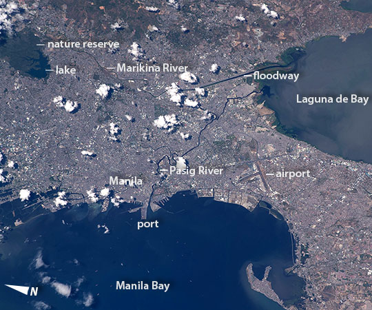 |
| Manila, Philippines From a point over the South China Sea a crew member aboard the International Space Station (ISS) took this oblique image of the blocky, red and gray urban pattern of Manila and surrounding cities, the political and economic hub of the Philippines. Manila is sandwiched between the salt water of Manila Bay with its scatter of anchored ships (at image lower left), and Laguna de Bay, the freshwater lake 9 km (5.4 miles) distant (at image top right). Even from the ISS, more than 500 km (310 miles) away, the fingers of the great docks at the port can be seen jutting into Manila Bay (at image center left). The center of the city lies immediately inland of the port, partly along the Pasig River. The airport appears south of the city center. A forested nature reserve with a lake is located within one of the mountainous areas surrounding the metro zone (at image top left). The combined population of Manila and neighboring Quezon City is 4.7 million people. Manila itself has one of the highest population densities in the world (42,857 per sq km). Its international trade connections are so widespread that in 2012, the Globalization and World Cities Research Network classed Manila as a global city. Manila's history has always been connected to trade: arriving from Mexico, the conquistadors founded Manila in 1571 and soon the city became the Far East anchor of the Acapulco-Manila Galleon trade route, connecting Spanish America with Asia. This represents one of the earliest examples of globalization. Dark lines of the waterways are prominent against the gray cityscape. The famous Pasig River winds through the middle of the city. The straight line of the Manggahan Floodway is a flood-control channel engineered to divert water from the Marikina River away from the city center and into Laguna de Bay. Engineering works along the floodway also control tidal saltwater flow into Laguna de Bay. |
| Images: | All Available Images Low-Resolution 133k |
|
| Mission: | ISS047 |
|
| Roll - Frame: | E - 99713 |
|
| Geographical Name: | PHILIPPINES |
|
| Features: | MANILA, HARBOR, URBAN AREA, AIRPORT, CANAL, BAY, LAGOON |
|
| Center Lat x Lon: | 14.5N x 121.0E |
|
| Film Exposure: | N=Normal exposure, U=Under exposed, O=Over exposed, F=out of Focus |
|
| Percentage of Cloud Cover-CLDP: | 10 |
|
| Camera:: | N6 |
|
| Camera Tilt: | 37 | LO=Low Oblique, HO=High Oblique, NV=Near Vertical |
| Camera Focal Length: | 400 |
|
| Nadir to Photo Center Direction: | E | The direction from the nadir to the center point, N=North, S=South, E=East, W=West |
| Stereo?: | Y=Yes there is an adjacent picture of the same area, N=No there isn't |
|
| Orbit Number: | |
|
| Date: | 20160506 | YYYYMMDD |
| Time: | 061039 | GMT HHMMSS |
| Nadir Lat: | 14.4N |
Latitude of suborbital point of spacecraft |
| Nadir Lon: | 118.3E |
Longitude of suborbital point of spacecraft |
| Sun Azimuth: | 279 | Clockwise angle in degrees from north to the sun measured at the nadir point |
| Space Craft Altitude: | 217 | nautical miles |
| Sun Elevation: | 59 | Angle in degrees between the horizon and the sun, measured at the nadir point |
| Land Views: | |
|
| Water Views: | BAY, CHANNEL, LAKE, RIVER, SEA |
|
| Atmosphere Views: | |
|
| Man Made Views: | AIRPORT |
|
| City Views: | MANILA |
|
Photo is not associated with any sequences | ||
| NASA Home Page |
JSC Home Page |
JSC Digital Image Collection |
Earth Science & Remote Sensing |
|
This service is provided by the International Space Station program and the JSC Earth Science & Remote Sensing Unit, ARES Division, Exploration Integration Science Directorate.

|