
Geographic Region: IRAN
Feature: KAVIR DESERT, SALT LAKE, SHORELINE, MESA
|
Geographic Region: IRAN Feature: KAVIR DESERT, SALT LAKE, SHORELINE, MESA |
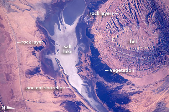 |
| Kavir Desert Landscape, Iran Part of the astronaut experience is seeing very many landscape and geology patterns, especially in deserts where vegetation is thin on the ground. A crew member aboard the International Space Station took this image of a circular hill in central Iran (image right). Even from 400 km up in space, this long-lens image shows details of the small (3.25 km long) flat hilltop. Numerous, multi-colored lines on the sides of the hill show that the hill is made of many thin layers of sedimentary rock. The neighboring dry lake has a white salt-covered surface. By contrast, the darkest areas are shrubby desert vegetation on the lowest slopes of the hill, the only zone where enough water concentrates to allow vegetation to grow. The astronaut might even be able to tell the difference between the long curved lines on the left of the image. One is an ancient shoreline formed when the lake contained permanent water--with waves strong enough to shape sediments into the form of a smooth beach. Another curved, slightly irregular line is a harder rock layer sticking out of the desert floor. |
| Images: | All Available Images Low-Resolution 123k |
|
| Mission: | ISS046 |
|
| Roll - Frame: | E - 693 |
|
| Geographical Name: | IRAN |
|
| Features: | KAVIR DESERT, SALT LAKE, SHORELINE, MESA |
|
| Center Lat x Lon: | 34.9N x 54.0E |
|
| Film Exposure: | N=Normal exposure, U=Under exposed, O=Over exposed, F=out of Focus |
|
| Percentage of Cloud Cover-CLDP: | 10 |
|
| Camera:: | N6 |
|
| Camera Tilt: | 04 | LO=Low Oblique, HO=High Oblique, NV=Near Vertical |
| Camera Focal Length: | 1150 |
|
| Nadir to Photo Center Direction: | NW | The direction from the nadir to the center point, N=North, S=South, E=East, W=West |
| Stereo?: | Y=Yes there is an adjacent picture of the same area, N=No there isn't |
|
| Orbit Number: | |
|
| Date: | 20151213 | YYYYMMDD |
| Time: | 110618 | GMT HHMMSS |
| Nadir Lat: | 34.8N |
Latitude of suborbital point of spacecraft |
| Nadir Lon: | 54.2E |
Longitude of suborbital point of spacecraft |
| Sun Azimuth: | 221 | Clockwise angle in degrees from north to the sun measured at the nadir point |
| Space Craft Altitude: | 217 | nautical miles |
| Sun Elevation: | 20 | Angle in degrees between the horizon and the sun, measured at the nadir point |
| Land Views: | DESERT, HILL |
|
| Water Views: | LAKE |
|
| Atmosphere Views: | |
|
| Man Made Views: | |
|
| City Views: | |
|
Photo is not associated with any sequences | ||
| NASA Home Page |
JSC Home Page |
JSC Digital Image Collection |
Earth Science & Remote Sensing |
|
This service is provided by the International Space Station program and the JSC Earth Science & Remote Sensing Unit, ARES Division, Exploration Integration Science Directorate.

|