Geographic Region: ALGERIA
Feature: COMPOUND LINEAR DUNES
|
Geographic Region: ALGERIA Feature: COMPOUND LINEAR DUNES |
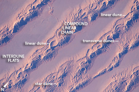 |
| Large linear dunes, Grand Erg Oriental (Great Eastern Sand Sea), Northern Algeria Looking almost vertically down onto the Sahara Desert a crew member aboard the International Space Station took this detailed, late afternoon image of the Grand Erg Oriental. Wind has organized vast quantities of sand into straight lines in what geologists call compound linear chains. The chains reach about 1.5 km wide in this view, and rise 150 m above the smooth intervening dune-free flats. Astronauts have a unique vantage point to view large areas of Algeria and Libya covered by these seas of sand. The compound chains are made up of numerous smaller linear dunes with sharply defined crests (also known as seif dunes after the Arabic word for "sword"). Linear dunes sometimes converge to a point with long tentacle-like arms called star dunes. Many examples of these appear in the image. An astronaut snapped a photo of individual, well-developed star dunes just 20 seconds after this photo was taken. (Click here to view it.) Geologists now know that different wind patterns are responsible for dune shapes. Winds that blow from one direction build linear dunes, and ultimately the chains seen in this image. The slight variation in wind direction pushes sand from one side of the dune and then from the other--making the sharp crests of the small linear dunes. These winds also stretch out the dune in the average direction of the winds (southward in this part of Algeria). By contrast, winds that blow with roughly equal strength from several directions make the star dunes--that stand at various points on top of the large chains. This suggests that the wind regime changed with time--first building the chains (over a long period of time), and then becoming more multi-directional so that the star dunes formed on top of the chains. Winds that blow strictly from one direction build a third kind of dune, the transverse dune that forms at right angles to the wind direction. Relatively small transverse dunes can be seen at many points in the image, made by north winds channeled by the chains, especially along the outer flanks of the chains and in hollows within the chains. Dunes are a favorite topic for orbiting photographers, partly because of their compelling patterns: Erg Oriental and Tifernine Dune Field. |
| Images: | All Available Images Low-Resolution 130k |
|
| Mission: | ISS046 |
|
| Roll - Frame: | E - 48626 |
|
| Geographical Name: | ALGERIA |
|
| Features: | COMPOUND LINEAR DUNES |
|
| Center Lat x Lon: | 29.8N x 5.6E |
|
| Film Exposure: | N=Normal exposure, U=Under exposed, O=Over exposed, F=out of Focus |
|
| Percentage of Cloud Cover-CLDP: | 10 |
|
| Camera:: | N6 |
|
| Camera Tilt: | 11 | LO=Low Oblique, HO=High Oblique, NV=Near Vertical |
| Camera Focal Length: | 1150 |
|
| Nadir to Photo Center Direction: | N | The direction from the nadir to the center point, N=North, S=South, E=East, W=West |
| Stereo?: | Y=Yes there is an adjacent picture of the same area, N=No there isn't |
|
| Orbit Number: | |
|
| Date: | 20160226 | YYYYMMDD |
| Time: | 162634 | GMT HHMMSS |
| Nadir Lat: | 29.2N |
Latitude of suborbital point of spacecraft |
| Nadir Lon: | 5.3E |
Longitude of suborbital point of spacecraft |
| Sun Azimuth: | 252 | Clockwise angle in degrees from north to the sun measured at the nadir point |
| Space Craft Altitude: | 215 | nautical miles |
| Sun Elevation: | 14 | Angle in degrees between the horizon and the sun, measured at the nadir point |
| Land Views: | DESERT, DUNE |
|
| Water Views: | |
|
| Atmosphere Views: | |
|
| Man Made Views: | |
|
| City Views: | |
|
Photo is not associated with any sequences | ||
| NASA Home Page |
JSC Home Page |
JSC Digital Image Collection |
Earth Science & Remote Sensing |
|
This service is provided by the International Space Station program and the JSC Earth Science & Remote Sensing Unit, ARES Division, Exploration Integration Science Directorate.

|