Geographic Region: WESTERN SAHARA
Feature: EL AAIUN, AL HAMRA R., AIRSTRIP, DUNES
|
Geographic Region: WESTERN SAHARA Feature: EL AAIUN, AL HAMRA R., AIRSTRIP, DUNES |
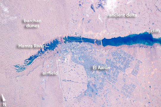 |
| The Hamra River and El AaiunAn astronaut aboard the International Space Station (ISS) put his or her earth-observation training to work in recognizing an unusual river that vanishes in a sand field well before it reaches the sea. The Hamra River (As Saquia al Hamra in Arabic) ends about 15 kilometers (9 miles) from the Atlantic Ocean in a dark blue lake. The river has cut into the landscape, making low cliffs on both sides. The river has its source in the mountains 300 kilometers (185 miles) inland, and it provides a persistent water supply for El Aaiun, the biggest city in Western Sahara. One of the most sparsely populated countries in the world, Western Sahara has a population of nearly half a million people; nearly 40 percent of them live in El Aaiun. The photograph was taken with the most powerful lens aboard the space station, and city blocks are easily detected in the gray cityscape. Even the white landing-marker lines on the airfield runways are visible, showing that the astronaut perfectly synchronized the camera's view-finder with the moving target. This allowed for one the best ground resolutions that can be achieved from the ISS: close to 3 meters per pixel. Small horn-shaped dunes are visible at the top left of the top image. The horns of these crescent dunes point south in the direction of dune movement. Sand from the dunes falls down the cliffs, making a spiky shoreline at the west end of the lake, and the dune field effectively prevents the river from reaching the sea. The dunes also restrict the westward expansion of the town. But scattered developments occupy an ancient delta of the river (top right) on more stable ground, where darker patches still indicate prior courses of the river. Related Images
|
| Images: | All Available Images Low-Resolution 92k |
|
| Mission: | ISS046 |
|
| Roll - Frame: | E - 46013 |
|
| Geographical Name: | WESTERN SAHARA |
|
| Features: | EL AAIUN, AL HAMRA R., AIRSTRIP, DUNES |
|
| Center Lat x Lon: | 27.1N x 13.2W |
|
| Film Exposure: | N=Normal exposure, U=Under exposed, O=Over exposed, F=out of Focus |
|
| Percentage of Cloud Cover-CLDP: | 10 |
|
| Camera:: | N6 |
|
| Camera Tilt: | 34 | LO=Low Oblique, HO=High Oblique, NV=Near Vertical |
| Camera Focal Length: | 1150 |
|
| Nadir to Photo Center Direction: | W | The direction from the nadir to the center point, N=North, S=South, E=East, W=West |
| Stereo?: | Y=Yes there is an adjacent picture of the same area, N=No there isn't |
|
| Orbit Number: | |
|
| Date: | 20160221 | YYYYMMDD |
| Time: | 105957 | GMT HHMMSS |
| Nadir Lat: | 28.0N |
Latitude of suborbital point of spacecraft |
| Nadir Lon: | 10.9W |
Longitude of suborbital point of spacecraft |
| Sun Azimuth: | 140 | Clockwise angle in degrees from north to the sun measured at the nadir point |
| Space Craft Altitude: | 217 | nautical miles |
| Sun Elevation: | 42 | Angle in degrees between the horizon and the sun, measured at the nadir point |
| Land Views: | |
|
| Water Views: | |
|
| Atmosphere Views: | |
|
| Man Made Views: | |
|
| City Views: | |
|
Photo is not associated with any sequences | ||
| NASA Home Page |
JSC Home Page |
JSC Digital Image Collection |
Earth Science & Remote Sensing |
|
This service is provided by the International Space Station program and the JSC Earth Science & Remote Sensing Unit, ARES Division, Exploration Integration Science Directorate.

|