Geographic Region: USA-HAWAII
Feature: MAUNA KEA VOL., OBSERVATORIES
|
Geographic Region: USA-HAWAII Feature: MAUNA KEA VOL., OBSERVATORIES |
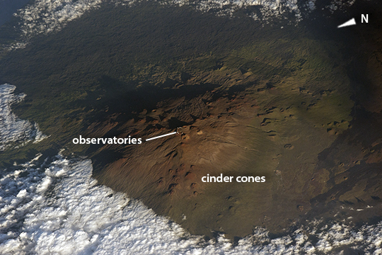 |
| Mauna Kea is the only volcano on the island of Hawaii that has evidence of glaciation. This photograph of Mauna Kea was taken by an astronaut as the International Space Station (ISS) passed over at approximately 5 p.m. local time. The late-afternoon lighting and oblique viewing angle accentuates the shadows, highlighting the white domes of the observatories along the crater rims. The angle also accentuates the numerous cinder cones and lava flows. Astronauts are often deprived of a three-dimensional sense of mountains because the ISS flies so far above Earth' surface. But the low Sun angle here gives a strong sense of the domed shape of this immense volcano. Several observatories appear as small white dots on the rim of Mauna Kea. As the highest volcano on the island of Hawaii (summit elevation 4,205 meters or 13,800 feet above sea level), it is an ideal location for the astronomical observatories set up by several countries and academic consortiums. Although Mauna Kea last erupted in 2460 BCE, the potential for renewed activity is high. Neighboring Mauna Loa volcano has erupted approximately every six years for the past 3,000 years. |
| Images: | All Available Images Low-Resolution 236k |
|
| Mission: | ISS045 |
|
| Roll - Frame: | E - 89403 |
|
| Geographical Name: | USA-HAWAII |
|
| Features: | MAUNA KEA VOL., OBSERVATORIES |
|
| Center Lat x Lon: | 19.8N x 155.4W |
|
| Film Exposure: | N=Normal exposure, U=Under exposed, O=Over exposed, F=out of Focus |
|
| Percentage of Cloud Cover-CLDP: | 25 |
|
| Camera:: | N6 |
|
| Camera Tilt: | HO | LO=Low Oblique, HO=High Oblique, NV=Near Vertical |
| Camera Focal Length: | 800 |
|
| Nadir to Photo Center Direction: | E | The direction from the nadir to the center point, N=North, S=South, E=East, W=West |
| Stereo?: | Y=Yes there is an adjacent picture of the same area, N=No there isn't |
|
| Orbit Number: | |
|
| Date: | 20151101 | YYYYMMDD |
| Time: | 030028 | GMT HHMMSS |
| Nadir Lat: | 19.6N |
Latitude of suborbital point of spacecraft |
| Nadir Lon: | 160.8W |
Longitude of suborbital point of spacecraft |
| Sun Azimuth: | 249 | Clockwise angle in degrees from north to the sun measured at the nadir point |
| Space Craft Altitude: | 215 | nautical miles |
| Sun Elevation: | 15 | Angle in degrees between the horizon and the sun, measured at the nadir point |
| Land Views: | |
|
| Water Views: | |
|
| Atmosphere Views: | |
|
| Man Made Views: | |
|
| City Views: | |
|
Photo is not associated with any sequences | ||
| NASA Home Page |
JSC Home Page |
JSC Digital Image Collection |
Earth Science & Remote Sensing |
|
This service is provided by the International Space Station program and the JSC Earth Science & Remote Sensing Unit, ARES Division, Exploration Integration Science Directorate.

|