Geographic Region: COOK ISLANDS
Feature: MANIHIKI ATOLL
|
Geographic Region: COOK ISLANDS Feature: MANIHIKI ATOLL |
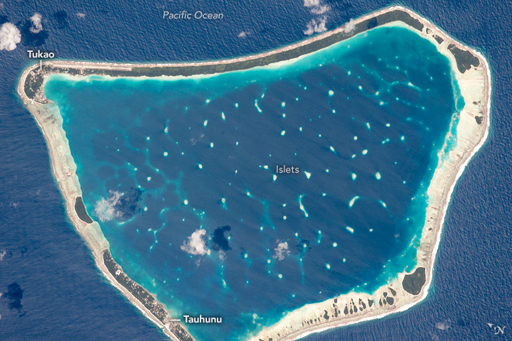 |
| Manihiki Atoll, Cook Islands, central Pacific Ocean With a high magnifications lens, an astronaut photographed almost the entire 10.5-km long (6.5 mi) Manihiki Island in the middle of the Pacific Ocean. Manihiki is one of the large islands in the remote Cook Island chain. From space it has the hallmarks of a classic atoll--with its fringing coral reef and a central lagoon. The coral lives in the warm, shallow waters which appear as the light blue zones around the main coastline and the numerous small islets within the lagoon. Most of the main atoll is made of sandy beaches without vegetation and appear white or cream due to dead coral broken up by waves. Soils develop on the highest parts and these support dense stands of dark green trees. A few clouds cast shadows on the water. Two small towns - Tauhunu and Tukao ( image lower left and top left) - appear as clusters of small bright patches etched into the forest. Aircraft land at the runway at Tukao after flying from New Zealand 3650 km (2270 mi) to the southwest. Tourism is the main economic activity, with diving in the lagoon and fishing in the waters outside the lagoon as the major attractions. Manihiki also produces rare black pearls produced by the local species of oyster. The Cook Islands are an independent nation, in "free association" with New Zealand. The population is small (15,000 in 2011) mainly on Manihiki and the 14 other larger islands. With greater opportunity available in New Zealand more than 60,000 Cook Islanders lived there by 2013. |
| Images: | All Available Images Low-Resolution 173k |
|
| Mission: | ISS045 |
|
| Roll - Frame: | E - 837 |
|
| Geographical Name: | COOK ISLANDS |
|
| Features: | MANIHIKI ATOLL |
|
| Center Lat x Lon: | 10.4S x 161W |
|
| Film Exposure: | N=Normal exposure, U=Under exposed, O=Over exposed, F=out of Focus |
|
| Percentage of Cloud Cover-CLDP: | 10 |
|
| Camera:: | N6 |
|
| Camera Tilt: | 10 | LO=Low Oblique, HO=High Oblique, NV=Near Vertical |
| Camera Focal Length: | 1150 |
|
| Nadir to Photo Center Direction: | N | The direction from the nadir to the center point, N=North, S=South, E=East, W=West |
| Stereo?: | Y=Yes there is an adjacent picture of the same area, N=No there isn't |
|
| Orbit Number: | |
|
| Date: | 20150913 | YYYYMMDD |
| Time: | 001528 | GMT HHMMSS |
| Nadir Lat: | 11S |
Latitude of suborbital point of spacecraft |
| Nadir Lon: | 161.2W |
Longitude of suborbital point of spacecraft |
| Sun Azimuth: | 301 | Clockwise angle in degrees from north to the sun measured at the nadir point |
| Space Craft Altitude: | 218 | nautical miles |
| Sun Elevation: | 62 | Angle in degrees between the horizon and the sun, measured at the nadir point |
| Land Views: | ATOLL, FOREST, ISLAND |
|
| Water Views: | LAGOON, OCEAN, REEF |
|
| Atmosphere Views: | |
|
| Man Made Views: | |
|
| City Views: | |
|
Photo is not associated with any sequences | ||
| NASA Home Page |
JSC Home Page |
JSC Digital Image Collection |
Earth Science & Remote Sensing |
|
This service is provided by the International Space Station program and the JSC Earth Science & Remote Sensing Unit, ARES Division, Exploration Integration Science Directorate.

|