
Geographic Region: SAUDI ARABIA
Feature: DESERT CANYONLANDS
|
Geographic Region: SAUDI ARABIA Feature: DESERT CANYONLANDS |
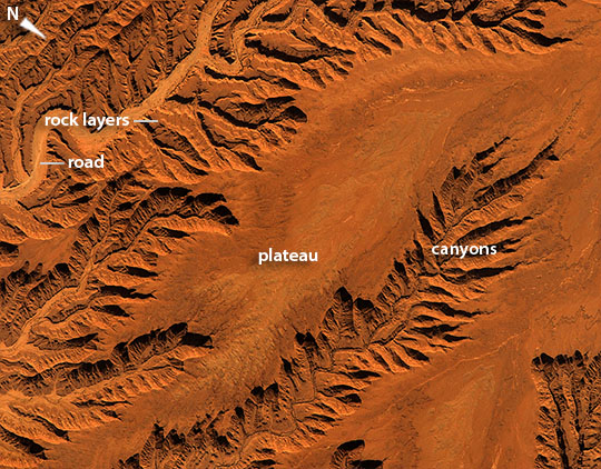 |
| Saudi Arabia Canyonlands Crews aboard the International Space Station are trained to use low sun angles to add a strong three-dimensional effect to flat landscapes--well illustrated by this image of central Saudi Arabia. The main river (image lower right), located 120 km (75 miles) south of the capital city Riyadh, has eroded its bed down into the rock layers making a small canyon 250 m deep (820 feet). This in turn has led all its tributaries to dig their own canyons--with the resulting elaborate, leaf-like pattern landscape that casts shadows in the late afternoon sun, attracting the astronaut's eye. This detailed image--the area covered is only 12.5 km (7.7 miles) across--shows a road following the main river. River beds are often the smoothest places in deserts for wheeled vehicles, connecting villages that also occupy river beds and terraces next to rivers, for access to well water. Dark dots in the main river bed are trees that only grow in the river beds where their roots are able to reach subsurface water. The center of the small plateau surface in the center of the image is a slightly different color from the area surrounding it. This is a lighter-toned layer of sedimentary rock, one of many in the area. Other thin layers make benches within the canyons (image lower left)--in the same style as seen in the Grand Canyon of the USA but on a much smaller scale. |
| Images: | All Available Images Low-Resolution 160k |
|
| Mission: | ISS045 |
|
| Roll - Frame: | E - 55901 |
|
| Geographical Name: | SAUDI ARABIA |
|
| Features: | DESERT CANYONLANDS |
|
| Center Lat x Lon: | 23.5N x 46.6E |
|
| Film Exposure: | N=Normal exposure, U=Under exposed, O=Over exposed, F=out of Focus |
|
| Percentage of Cloud Cover-CLDP: | 0 |
|
| Camera:: | N6 |
|
| Camera Tilt: | 26 | LO=Low Oblique, HO=High Oblique, NV=Near Vertical |
| Camera Focal Length: | 1150 |
|
| Nadir to Photo Center Direction: | W | The direction from the nadir to the center point, N=North, S=South, E=East, W=West |
| Stereo?: | Y=Yes there is an adjacent picture of the same area, N=No there isn't |
|
| Orbit Number: | |
|
| Date: | 20151010 | YYYYMMDD |
| Time: | 120330 | GMT HHMMSS |
| Nadir Lat: | 22.8N |
Latitude of suborbital point of spacecraft |
| Nadir Lon: | 48.2E |
Longitude of suborbital point of spacecraft |
| Sun Azimuth: | 247 | Clockwise angle in degrees from north to the sun measured at the nadir point |
| Space Craft Altitude: | 214 | nautical miles |
| Sun Elevation: | 31 | Angle in degrees between the horizon and the sun, measured at the nadir point |
| Land Views: | PLATEAU |
|
| Water Views: | RIVER |
|
| Atmosphere Views: | |
|
| Man Made Views: | |
|
| City Views: | |
|
Photo is not associated with any sequences | ||
| NASA Home Page |
JSC Home Page |
JSC Digital Image Collection |
Earth Science & Remote Sensing |
|
This service is provided by the International Space Station program and the JSC Earth Science & Remote Sensing Unit, ARES Division, Exploration Integration Science Directorate.

|