Geographic Region: AUSTRALIA-WA
Feature: L. HINDS, MORTLOCK RIVER, AGR.
|
Geographic Region: AUSTRALIA-WA Feature: L. HINDS, MORTLOCK RIVER, AGR. |
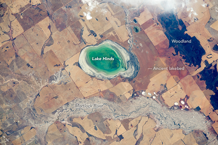 |
| Lake Hinds, Western Australia Using a powerful lens, an astronaut aboard the International Space Station photographed this small but eye-catching dry lake not far from Perth, Australia. The modern lake floor is only 5 kilometers in length and it is usually dry, with an exposed bed of white salt. But green water in this view indicates that recent rains had partly filled the lake. In this increasingly arid inland sector of the wheat belt, the Mortlock River carries more dissolved salt than other rivers in the area. Smooth-edged, dry lake beds are well-known features of the landscape in Australia. Numerous "bath-tub rings" show the prior water levels in the lake. It was once much larger, as shown by another series of parallel, hard-to-detect rings east of the lake. Today this ancient lake floor is among the most fertile agricultural parcels in the area. Most of Australia is arid or semi-arid, such that agriculture is mostly limited to the continent's wet margins. In this slightly wetter, southwest region around Perth, rectangular wheat fields (aligned north-south) are densely packed. Not very far to the east, all agriculture stops and large sheep ranches dominate the land use. The hilly country of Mount Matilda and Mount O'Brien remain wooded because they are too rough to plough. |
| Images: | All Available Images Low-Resolution 192k |
|
| Mission: | ISS045 |
|
| Roll - Frame: | E - 167797 |
|
| Geographical Name: | AUSTRALIA-WA |
|
| Features: | L. HINDS, MORTLOCK RIVER, AGR. |
|
| Center Lat x Lon: | 30.8S x 116.6E |
|
| Film Exposure: | N=Normal exposure, U=Under exposed, O=Over exposed, F=out of Focus |
|
| Percentage of Cloud Cover-CLDP: | 10 |
|
| Camera:: | N6 |
|
| Camera Tilt: | 18 | LO=Low Oblique, HO=High Oblique, NV=Near Vertical |
| Camera Focal Length: | 800 |
|
| Nadir to Photo Center Direction: | S | The direction from the nadir to the center point, N=North, S=South, E=East, W=West |
| Stereo?: | Y=Yes there is an adjacent picture of the same area, N=No there isn't |
|
| Orbit Number: | |
|
| Date: | 20151203 | YYYYMMDD |
| Time: | 065819 | GMT HHMMSS |
| Nadir Lat: | 29.7S |
Latitude of suborbital point of spacecraft |
| Nadir Lon: | 117.0E |
Longitude of suborbital point of spacecraft |
| Sun Azimuth: | 270 | Clockwise angle in degrees from north to the sun measured at the nadir point |
| Space Craft Altitude: | 220 | nautical miles |
| Sun Elevation: | 50 | Angle in degrees between the horizon and the sun, measured at the nadir point |
| Land Views: | |
|
| Water Views: | |
|
| Atmosphere Views: | |
|
| Man Made Views: | |
|
| City Views: | |
|
Photo is not associated with any sequences | ||
| NASA Home Page |
JSC Home Page |
JSC Digital Image Collection |
Earth Science & Remote Sensing |
|
This service is provided by the International Space Station program and the JSC Earth Science & Remote Sensing Unit, ARES Division, Exploration Integration Science Directorate.

|